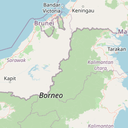
Distance Between Brunei Cities
Distance from Brunei to major cities are listed below, or choose from the list to calculate distance. 3 major city distances are calculated in Brunei country. The GPS coordinates of Brunei is 4° 32´ 6.9972'' N and 114° 43´ 39.6084'' E. Some of the leading cities of Brunei are Bandar Seri Begawan, Kuala Belait, Tutong.
Leaflet | © OpenStreetMap
Distances of Brunei Cities
List of Brunei cities with distance in kilometers.
Visit city distance page to calculate distance to all cities.
| City | Distance |
|---|---|
| Bandar Seri Begawan to Kuala Belait | 89 km |
| Tutong |
Click on the city name to list the sub cities within the major city, and calculate the distance between cities.