Distance Between Syria Cities
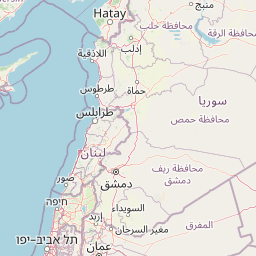
Distance from Syria to major cities are listed below, or choose from the list to calculate distance. 13 major city distances are calculated in Syria country. The GPS coordinates of Syria is 34° 48´ 7.4664'' N and 38° 59´ 48.5340'' E. Some of the leading cities of Syria are Aleppo, Damascus, Homs.


Leaflet | © OpenStreetMap
Distances of Syria Cities
List of Syria cities with distance in kilometers.
Visit city distance page to calculate distance to all cities.
| City | Distance |
|---|---|
| Aleppo to Damascus | 310 km |
| Homs to Hamah | 45 km |
| Latakia to Deir ez-Zor | 395 km |
| Ar Raqqah to Idlib | 214 km |
| Dar'a to Tartouss | 253 km |
| Al Hasakah to As Suwayda' | 569 km |
| Al Qunaytirah |
The Nearest Neighboring Countries to Syria
Distance from Syria to the nearest countries.
The distance between Syria and the nearest country Lebanon is 306 km.
| Country | Distance to Syria |
|---|---|
| Lebanon | 306 km |
| Iraq | 466 km |
| Palestinian Territory | 467 km |
| Cyprus | 509 km |
| Jordan | 535 km |
| Israel | 569 km |
| Turkey | 570 km |
| Armenia | 792 km |
| Georgia | 917 km |
Click on the city name to list the sub cities within the major city, and calculate the distance between cities.