Distance Between Venezuela Cities
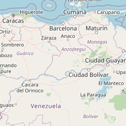
Distance from Venezuela to major cities are listed below, or choose from the list to calculate distance. 24 major city distances are calculated in Venezuela country. The GPS coordinates of Venezuela is 6° 25´ 25.5000'' N and 66° 35´ 23.0244'' W. Some of the leading cities of Venezuela are Caracas, Maracaibo, Maracay.


Leaflet | © OpenStreetMap
Distances of Venezuela Cities
List of Venezuela cities with distance in kilometers.
Visit city distance page to calculate distance to all cities.
| City | Distance |
|---|---|
| Caracas to Maracaibo | 521 km |
| Maracay to Valencia | 46 km |
| Barquisimeto to Barcelona | 506 km |
| Maturin to Barinas | 781 km |
| Ciudad Bolivar to Merida | 838 km |
| Cumana to San Cristobal | 932 km |
| Coro to Los Teques | 310 km |
| Guanare to San Juan de los Morros | 279 km |
| San Fernando Apure to San Carlos | 232 km |
| San Felipe to Puerto Ayacucho | 534 km |
| Tucupita to Trujillo | 921 km |
| La Asuncion to La Guaira | 339 km |
The Nearest Neighboring Countries to Venezuela
Distance from Venezuela to the nearest countries.
The distance between Venezuela and the nearest country Bonaire, Saint Eustatius and Saba is 665 km.
| Country | Distance to Venezuela |
|---|---|
| Bonaire, Saint Eustatius and Saba | 665 km |
| Netherlands Antilles | 668 km |
| Curacao | 691 km |
| Trinidad and Tobago | 757 km |
| Aruba | 773 km |
| Grenada | 831 km |
| Guyana | 865 km |
| Colombia | 878 km |
| Saint Vincent and the Grenadines | 962 km |
Click on the city name to list the sub cities within the major city, and calculate the distance between cities.