Distance from Aba to Illela
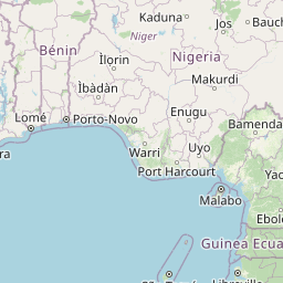
Distance between Aba and Illela is 1066 kilometers (662 miles).
Distance Map Between Aba and Illela
Aba, Umuahia, Nigeria ↔ Illela, Tahoua, Niger = 662 miles = 1066 km.


Leaflet | © OpenStreetMap
How far is it between Aba and Illéla
Aba is located in Nigeria with (5.1066,7.3667) coordinates and Illela is located in Niger with (14.4605,5.2437) coordinates. The calculated flying distance from Aba to Illela is equal to 662 miles which is equal to 1066 km.
| City/Place | Latitude and Longitude | GPS Coordinates |
|---|---|---|
| Aba | 5.1066, 7.3667 | 5° 6´ 23.6880'' N 7° 22´ 0.0120'' E |
| Illela | 14.4605, 5.2437 | 14° 27´ 37.8000'' N 5° 14´ 37.3200'' E |
Aba, Umuahia, Nigeria
Related Distances from Aba
| Cities | Distance |
|---|---|
| Aba to Diffa | 1452 km |
| Aba to Agadez | 1696 km |
| Aba to Zinder | 1276 km |
| Aba to Dosso | 1547 km |
| Aba to Gaya 2 | 1203 km |
Illela, Tahoua, Niger
Related Distances to Illela
| Cities | Distance |
|---|---|
| Kano to Illela 2 | 557 km |
| Lagos to Illela 2 | 1246 km |
| Zaria to Illela 2 | 568 km |
| Maiduguri to Illela 2 | 1090 km |
| Jos to Illela 2 | 826 km |