Distance from Aland to Ullal
Distance between Aland and Ullal is 559 kilometers (348 miles).
Driving distance from Aland to Ullal is 718 kilometers (446 miles).
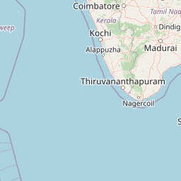
Distance Map Between Aland and Ullal
Aland, Bangalore, India ↔ Ullal, Bangalore, India = 348 miles = 559 km.


How far is it between Aland and Ullal
Aland is located in India with (17.5643,76.5685) coordinates and Ullal is located in India with (12.8108,74.8629) coordinates. The calculated flying distance from Aland to Ullal is equal to 348 miles which is equal to 559 km.
If you want to go by car, the driving distance between Aland and Ullal is 717.88 km. If you ride your car with an average speed of 112 kilometers/hour (70 miles/h), travel time will be 06 hours 24 minutes. Please check the avg. speed travel time table on the right for various options.
Difference between fly and go by a car is 159 km.
| City/Place | Latitude and Longitude | GPS Coordinates |
|---|---|---|
| Aland | 17.5643, 76.5685 | 17° 33´ 51.3000'' N 76° 34´ 6.7440'' E |
| Ullal | 12.8108, 74.8629 | 12° 48´ 38.8800'' N 74° 51´ 46.4400'' E |
Estimated Travel Time Between Aland and Ullal
| Average Speed | Travel Time |
|---|---|
| 30 mph (48 km/h) | 14 hours 57 minutes |
| 40 mph (64 km/h) | 11 hours 13 minutes |
| 50 mph (80 km/h) | 08 hours 58 minutes |
| 60 mph (97 km/h) | 07 hours 24 minutes |
| 70 mph (112 km/h) | 06 hours 24 minutes |
| 75 mph (120 km/h) | 05 hours 58 minutes |
Related Distances from Aland
| Cities | Distance |
|---|---|
| Aland to Gulbarga | 43 km |
| Aland to Bidar | 141 km |
| Aland to Basavakalyan | 70 km |
| Aland to Bijapur | 159 km |
| Aland to Indi | 111 km |
Related Distances to Ullal
| Cities | Distance |
|---|---|
| Mangalore to Ullal | 15 km |
| Mysore to Ullal | 253 km |
| Chikmagalur to Ullal | 154 km |
| Puttur to Ullal | 53 km |
| Nelamangala to Ullal | 325 km |