Distance from Ati to Doba
Distance between Ati and Doba is 533 kilometers (331 miles).
Driving distance from Ati to Doba is 940 kilometers (584 miles).
Distance Map Between Ati and Doba
Ati, Chad ↔ Doba, Chad = 331 miles = 533 km.


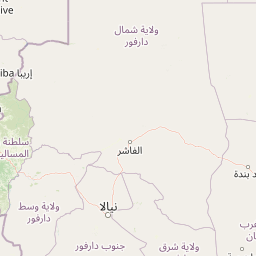


Leaflet | © OpenStreetMap
How far is it between Ati and Doba
Ati is located in Chad with (13.2154,18.3353) coordinates and Doba is located in Chad with (8.65,16.85) coordinates. The calculated flying distance from Ati to Doba is equal to 331 miles which is equal to 533 km.
If you want to go by car, the driving distance between Ati and Doba is 939.97 km. If you ride your car with an average speed of 112 kilometers/hour (70 miles/h), travel time will be 08 hours 23 minutes. Please check the avg. speed travel time table on the right for various options.
Difference between fly and go by a car is 407 km.
| City/Place | Latitude and Longitude | GPS Coordinates |
|---|---|---|
| Ati | 13.2154, 18.3353 | 13° 12´ 55.4400'' N 18° 20´ 7.0800'' E |
| Doba | 8.65, 16.85 | 8° 39´ 0.0000'' N 16° 51´ 0.0000'' E |
Estimated Travel Time Between Ati and Doba
| Average Speed | Travel Time |
|---|---|
| 30 mph (48 km/h) | 19 hours 34 minutes |
| 40 mph (64 km/h) | 14 hours 41 minutes |
| 50 mph (80 km/h) | 11 hours 44 minutes |
| 60 mph (97 km/h) | 09 hours 41 minutes |
| 70 mph (112 km/h) | 08 hours 23 minutes |
| 75 mph (120 km/h) | 07 hours 49 minutes |
Ati, Chad
Related Distances from Ati
| Cities | Distance |
|---|---|
| Ati to N Djamena | 443 km |
| Ati to Koumra | 824 km |
| Ati to Lai | 823 km |
| Ati to Abeche | 310 km |
| Ati to Pala | 869 km |
Doba, Chad
Related Distances to Doba
| Cities | Distance |
|---|---|
| Bongor to Doba | 260 km |
| Bitkine to Doba | 680 km |
| Ati to Doba | 940 km |
| Benoy to Doba | 164 km |