Distance from Avadi to Tirunelveli
Distance between Avadi and Tirunelveli is 555 kilometers (345 miles).
Driving distance from Avadi to Tirunelveli is 617 kilometers (383 miles).
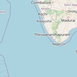
Distance Map Between Avadi and Tirunelveli
Avadi, Chennai, India ↔ Tirunelveli, Chennai, India = 345 miles = 555 km.


How far is it between Āvadi and Tirunelveli
Avadi is located in India with (13.1147,80.1098) coordinates and Tirunelveli is located in India with (8.7252,77.6845) coordinates. The calculated flying distance from Avadi to Tirunelveli is equal to 345 miles which is equal to 555 km.
If you want to go by car, the driving distance between Avadi and Tirunelveli is 617 km. If you ride your car with an average speed of 112 kilometers/hour (70 miles/h), travel time will be 05 hours 30 minutes. Please check the avg. speed travel time table on the right for various options.
Difference between fly and go by a car is 62 km.
| City/Place | Latitude and Longitude | GPS Coordinates |
|---|---|---|
| Avadi | 13.1147, 80.1098 | 13° 6´ 52.9200'' N 80° 6´ 35.3160'' E |
| Tirunelveli | 8.7252, 77.6845 | 8° 43´ 30.6480'' N 77° 41´ 4.2720'' E |
Estimated Travel Time Between Āvadi and Tirunelveli
| Average Speed | Travel Time |
|---|---|
| 30 mph (48 km/h) | 12 hours 51 minutes |
| 40 mph (64 km/h) | 09 hours 38 minutes |
| 50 mph (80 km/h) | 07 hours 42 minutes |
| 60 mph (97 km/h) | 06 hours 21 minutes |
| 70 mph (112 km/h) | 05 hours 30 minutes |
| 75 mph (120 km/h) | 05 hours 08 minutes |
Related Distances from Avadi
| Cities | Distance |
|---|---|
| Avadi to Manali | 26 km |
| Avadi to Pallavaram | 28 km |
| Avadi to Guduvancheri | 42 km |
| Avadi to Sriperumbudur | 30 km |
| Avadi to Tinnanur | 10 km |
Related Distances to Tirunelveli
| Cities | Distance |
|---|---|
| Alangulam to Tirunelveli | 28 km |
| Madurai to Tirunelveli | 158 km |
| Surandai to Tirunelveli | 46 km |
| Sattur to Tirunelveli | 82 km |
| Sivagiri to Tirunelveli | 90 km |