Distance from Bagasra to Rajkot
Distance between Bagasra and Rajkot is 91 kilometers (57 miles).
Driving distance from Bagasra to Rajkot is 104 kilometers (65 miles).
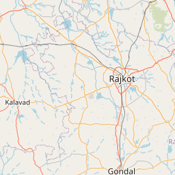
Distance Map Between Bagasra and Rajkot
Bagasra, Ghandinagar, India ↔ Rajkot, Ghandinagar, India = 57 miles = 91 km.


How far is it between Bagasra and Rājkot
Bagasra is located in India with (21.4872,70.9552) coordinates and Rajkot is located in India with (22.2916,70.7932) coordinates. The calculated flying distance from Bagasra to Rajkot is equal to 57 miles which is equal to 91 km.
If you want to go by car, the driving distance between Bagasra and Rajkot is 103.86 km. If you ride your car with an average speed of 112 kilometers/hour (70 miles/h), travel time will be 00 hours 55 minutes. Please check the avg. speed travel time table on the right for various options.
Difference between fly and go by a car is 13 km.
| City/Place | Latitude and Longitude | GPS Coordinates |
|---|---|---|
| Bagasra | 21.4872, 70.9552 | 21° 29´ 13.8840'' N 70° 57´ 18.5760'' E |
| Rajkot | 22.2916, 70.7932 | 22° 17´ 29.7960'' N 70° 47´ 35.5920'' E |
Estimated Travel Time Between Bagasra and Rājkot
| Average Speed | Travel Time |
|---|---|
| 30 mph (48 km/h) | 02 hours 09 minutes |
| 40 mph (64 km/h) | 01 hours 37 minutes |
| 50 mph (80 km/h) | 01 hours 17 minutes |
| 60 mph (97 km/h) | 01 hours 04 minutes |
| 70 mph (112 km/h) | 00 hours 55 minutes |
| 75 mph (120 km/h) | 00 hours 51 minutes |
Related Distances from Bagasra
| Cities | Distance |
|---|---|
| Bagasra to Rajkot | 104 km |
| Bagasra to Jetpur | 54 km |
| Bagasra to Vadodara | 338 km |
| Bagasra to Junagadh | 65 km |
| Bagasra to Porbandar | 169 km |
Related Distances to Rajkot
| Cities | Distance |
|---|---|
| Limbdi to Rajkot | 117 km |
| Ahmedabad to Rajkot | 219 km |
| Jasdan to Rajkot | 59 km |
| Kalavad to Rajkot | 48 km |
| Babra to Rajkot | 80 km |