Distance from Becontree to Sutton
Distance between Becontree and Sutton is 32 kilometers (20 miles).
Driving distance from Becontree to Sutton is 74 kilometers (46 miles).
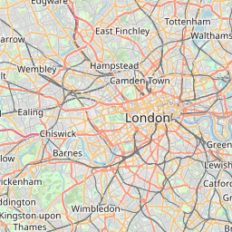
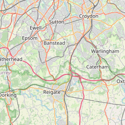
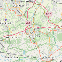
Distance Map Between Becontree and Sutton
Becontree, London, United Kingdom ↔ Sutton, London, United Kingdom = 20 miles = 32 km.

How far is it between Becontree and Sutton
Becontree is located in United Kingdom with (51.5529,0.129) coordinates and Sutton is located in United Kingdom with (51.35,-0.2) coordinates. The calculated flying distance from Becontree to Sutton is equal to 20 miles which is equal to 32 km.
If you want to go by car, the driving distance between Becontree and Sutton is 74 km. If you ride your car with an average speed of 112 kilometers/hour (70 miles/h), travel time will be 00 hours 39 minutes. Please check the avg. speed travel time table on the right for various options.
Difference between fly and go by a car is 42 km.
| City/Place | Latitude and Longitude | GPS Coordinates |
|---|---|---|
| Becontree | 51.5529, 0.129 | 51° 33´ 10.4400'' N 0° 7´ 44.4000'' E |
| Sutton | 51.35, -0.2 | 51° 21´ 0.0000'' N 0° 12´ 0.0000'' W |
Estimated Travel Time Between Becontree and Sutton
| Average Speed | Travel Time |
|---|---|
| 30 mph (48 km/h) | 01 hours 32 minutes |
| 40 mph (64 km/h) | 01 hours 09 minutes |
| 50 mph (80 km/h) | 00 hours 55 minutes |
| 60 mph (97 km/h) | 00 hours 45 minutes |
| 70 mph (112 km/h) | 00 hours 39 minutes |
| 75 mph (120 km/h) | 00 hours 37 minutes |
Related Distances from Becontree
| Cities | Distance |
|---|---|
| Becontree to Dagenham | 3 km |
| Becontree to East Grinstead | 74 km |
| Becontree to Exeter | 338 km |
| Becontree to Trowbridge | 249 km |
| Becontree to City Of London | 19 km |
Related Distances to Sutton
| Cities | Distance |
|---|---|
| Birmingham to Sutton Coldfield | 15 km |
| City Of London to Sutton | 25 km |
| Chessington to Sutton | 11 km |
| Acton to Sutton | 29 km |
| Chelsea to Sutton | 25 km |