Distance from Bedford to Sutton
Distance between Bedford and Sutton is 89 kilometers (55 miles).
Driving distance from Bedford to Sutton is 144 kilometers (89 miles).
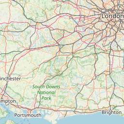
Distance Map Between Bedford and Sutton
Bedford, London, United Kingdom ↔ Sutton, London, United Kingdom = 55 miles = 89 km.


How far is it between Bedford and Sutton
Bedford is located in United Kingdom with (52.1346,-0.4663) coordinates and Sutton is located in United Kingdom with (51.35,-0.2) coordinates. The calculated flying distance from Bedford to Sutton is equal to 55 miles which is equal to 89 km.
If you want to go by car, the driving distance between Bedford and Sutton is 143.52 km. If you ride your car with an average speed of 112 kilometers/hour (70 miles/h), travel time will be 01 hours 16 minutes. Please check the avg. speed travel time table on the right for various options.
Difference between fly and go by a car is 55 km.
| City/Place | Latitude and Longitude | GPS Coordinates |
|---|---|---|
| Bedford | 52.1346, -0.4663 | 52° 8´ 4.5240'' N 0° 27´ 58.7520'' W |
| Sutton | 51.35, -0.2 | 51° 21´ 0.0000'' N 0° 12´ 0.0000'' W |
Estimated Travel Time Between Bedford and Sutton
| Average Speed | Travel Time |
|---|---|
| 30 mph (48 km/h) | 02 hours 59 minutes |
| 40 mph (64 km/h) | 02 hours 14 minutes |
| 50 mph (80 km/h) | 01 hours 47 minutes |
| 60 mph (97 km/h) | 01 hours 28 minutes |
| 70 mph (112 km/h) | 01 hours 16 minutes |
| 75 mph (120 km/h) | 01 hours 11 minutes |
Related Distances from Bedford
| Cities | Distance |
|---|---|
| Bedford to City Of London | 94 km |
| Bedford to Cambridge | 50 km |
| Bedford to Manchester | 265 km |
| Bedford to Birmingham | 133 km |
| Bedford to Milton Keynes | 30 km |
Related Distances to Sutton
| Cities | Distance |
|---|---|
| Birmingham to Sutton Coldfield | 15 km |
| City Of London to Sutton | 25 km |
| Chessington to Sutton | 11 km |
| Acton to Sutton | 29 km |
| Chelsea to Sutton | 25 km |