Distance from Bel Air South to Dundalk
Distance between Bel Air South and Dundalk is 33 kilometers (21 miles).
Driving distance from Bel Air South to Dundalk is 40 kilometers (25 miles).
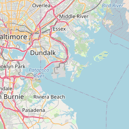
Distance Map Between Bel Air South and Dundalk
Bel Air South, Annapolis, United States ↔ Dundalk, Annapolis, United States = 21 miles = 33 km.


How far is it between Bel Air South and Dundalk
Bel Air South is located in United States with (39.5051,-76.3198) coordinates and Dundalk is located in United States with (39.2507,-76.5205) coordinates. The calculated flying distance from Bel Air South to Dundalk is equal to 21 miles which is equal to 33 km.
If you want to go by car, the driving distance between Bel Air South and Dundalk is 39.88 km. If you ride your car with an average speed of 112 kilometers/hour (70 miles/h), travel time will be 00 hours 21 minutes. Please check the avg. speed travel time table on the right for various options.
Difference between fly and go by a car is 7 km.
| City/Place | Latitude and Longitude | GPS Coordinates |
|---|---|---|
| Bel Air South | 39.5051, -76.3198 | 39° 30´ 18.2160'' N 76° 19´ 11.1720'' W |
| Dundalk | 39.2507, -76.5205 | 39° 15´ 2.3760'' N 76° 31´ 13.8720'' W |
Estimated Travel Time Between Bel Air South and Dundalk
| Average Speed | Travel Time |
|---|---|
| 30 mph (48 km/h) | 00 hours 49 minutes |
| 40 mph (64 km/h) | 00 hours 37 minutes |
| 50 mph (80 km/h) | 00 hours 29 minutes |
| 60 mph (97 km/h) | 00 hours 24 minutes |
| 70 mph (112 km/h) | 00 hours 21 minutes |
| 75 mph (120 km/h) | 00 hours 19 minutes |
Related Distances from Bel Air South
| Cities | Distance |
|---|---|
| Bel Air South to Baltimore | 48 km |
| Bel Air South to Easton 3 | 146 km |
| Bel Air South to Elkridge | 54 km |
| Bel Air South to Bethesda | 103 km |
| Bel Air South to Ellicott City | 62 km |
Related Distances to Dundalk
| Cities | Distance |
|---|---|
| Laurel to Dundalk | 42 km |
| Hanover to Dundalk | 25 km |
| Owings Mills to Dundalk | 47 km |
| Essex to Dundalk | 11 km |
| Ellicott City to Dundalk | 33 km |