Distance from Bhuj to Mandvi
Distance between Bhuj and Mandvi is 57 kilometers (35 miles).
Driving distance from Bhuj to Mandvi is 60 kilometers (37 miles).
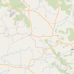
Distance Map Between Bhuj and Mandvi
Bhuj, Ghandinagar, India ↔ Mandvi, Ghandinagar, India = 35 miles = 57 km.


How far is it between Bhuj and Māndvi
Bhuj is located in India with (23.254,69.6693) coordinates and Mandvi is located in India with (22.8328,69.3524) coordinates. The calculated flying distance from Bhuj to Mandvi is equal to 35 miles which is equal to 57 km.
If you want to go by car, the driving distance between Bhuj and Mandvi is 59.9 km. If you ride your car with an average speed of 112 kilometers/hour (70 miles/h), travel time will be 00 hours 32 minutes. Please check the avg. speed travel time table on the right for various options.
Difference between fly and go by a car is 3 km.
| City/Place | Latitude and Longitude | GPS Coordinates |
|---|---|---|
| Bhuj | 23.254, 69.6693 | 23° 15´ 14.2920'' N 69° 40´ 9.4080'' E |
| Mandvi | 22.8328, 69.3524 | 22° 49´ 58.1520'' N 69° 21´ 8.5320'' E |
Estimated Travel Time Between Bhuj and Māndvi
| Average Speed | Travel Time |
|---|---|
| 30 mph (48 km/h) | 01 hours 14 minutes |
| 40 mph (64 km/h) | 00 hours 56 minutes |
| 50 mph (80 km/h) | 00 hours 44 minutes |
| 60 mph (97 km/h) | 00 hours 37 minutes |
| 70 mph (112 km/h) | 00 hours 32 minutes |
| 75 mph (120 km/h) | 00 hours 29 minutes |
Related Distances from Bhuj
| Cities | Distance |
|---|---|
| Bhuj to Rapar | 128 km |
| Bhuj to Rajkot | 236 km |
| Bhuj to Mandvi | 60 km |
| Bhuj to Dwarka | 392 km |
| Bhuj to Than | 231 km |
Related Distances to Mandvi
| Cities | Distance |
|---|---|
| Bardoli to Mandvi 2 | 29 km |
| Gandhidham to Mandvi | 98 km |
| Bhuj to Mandvi | 60 km |
| Kandla to Mandvi | 110 km |
| Ahmedabad to Mandvi | 388 km |