Distance from Bocaue to Porac
Distance between Bocaue and Porac is 51 kilometers (32 miles).
Driving distance from Bocaue to Porac is 68 kilometers (42 miles).
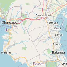
Distance Map Between Bocaue and Porac
Bocaue, , Philippines ↔ Porac, , Philippines = 32 miles = 51 km.


How far is it between Bocaue and Porac
Bocaue is located in Philippines with (14.7983,120.9261) coordinates and Porac is located in Philippines with (15.0711,120.5423) coordinates. The calculated flying distance from Bocaue to Porac is equal to 32 miles which is equal to 51 km.
If you want to go by car, the driving distance between Bocaue and Porac is 67.63 km. If you ride your car with an average speed of 112 kilometers/hour (70 miles/h), travel time will be 00 hours 36 minutes. Please check the avg. speed travel time table on the right for various options.
Difference between fly and go by a car is 17 km.
| City/Place | Latitude and Longitude | GPS Coordinates |
|---|---|---|
| Bocaue | 14.7983, 120.9261 | 14° 47´ 53.9880'' N 120° 55´ 33.9960'' E |
| Porac | 15.0711, 120.5423 | 15° 4´ 15.9600'' N 120° 32´ 32.2800'' E |
Estimated Travel Time Between Bocaue and Porac
| Average Speed | Travel Time |
|---|---|
| 30 mph (48 km/h) | 01 hours 24 minutes |
| 40 mph (64 km/h) | 01 hours 03 minutes |
| 50 mph (80 km/h) | 00 hours 50 minutes |
| 60 mph (97 km/h) | 00 hours 41 minutes |
| 70 mph (112 km/h) | 00 hours 36 minutes |
| 75 mph (120 km/h) | 00 hours 33 minutes |
Related Distances from Bocaue
| Cities | Distance |
|---|---|
| Bocaue to Malolos | 18 km |
| Bocaue to San Jose Del Monte | 19 km |
| Bocaue to Meycauayan | 8 km |
| Bocaue to Marilao | 5 km |
| Bocaue to Pulilan | 23 km |
Related Distances to Porac
| Cities | Distance |
|---|---|
| Angeles City to Porac | 14 km |
| Mabalacat City to Porac | 30 km |
| Mexico to Porac | 30 km |
| Lubao to Porac | 20 km |
| Magalang to Porac | 49 km |