Distance from Bocaue to Ramos
Distance between Bocaue and Ramos is 101 kilometers (63 miles).
Driving distance from Bocaue to Ramos is 123 kilometers (76 miles).
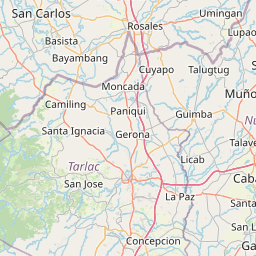
Distance Map Between Bocaue and Ramos
Bocaue, , Philippines ↔ Ramos, , Philippines = 63 miles = 101 km.


How far is it between Bocaue and Ramos
Bocaue is located in Philippines with (14.7983,120.9261) coordinates and Ramos is located in Philippines with (15.6653,120.6406) coordinates. The calculated flying distance from Bocaue to Ramos is equal to 63 miles which is equal to 101 km.
If you want to go by car, the driving distance between Bocaue and Ramos is 122.55 km. If you ride your car with an average speed of 112 kilometers/hour (70 miles/h), travel time will be 01 hours 05 minutes. Please check the avg. speed travel time table on the right for various options.
Difference between fly and go by a car is 22 km.
| City/Place | Latitude and Longitude | GPS Coordinates |
|---|---|---|
| Bocaue | 14.7983, 120.9261 | 14° 47´ 53.9880'' N 120° 55´ 33.9960'' E |
| Ramos | 15.6653, 120.6406 | 15° 39´ 55.0800'' N 120° 38´ 26.1600'' E |
Estimated Travel Time Between Bocaue and Ramos
| Average Speed | Travel Time |
|---|---|
| 30 mph (48 km/h) | 02 hours 33 minutes |
| 40 mph (64 km/h) | 01 hours 54 minutes |
| 50 mph (80 km/h) | 01 hours 31 minutes |
| 60 mph (97 km/h) | 01 hours 15 minutes |
| 70 mph (112 km/h) | 01 hours 05 minutes |
| 75 mph (120 km/h) | 01 hours 01 minutes |
Related Distances from Bocaue
| Cities | Distance |
|---|---|
| Bocaue to Malolos | 18 km |
| Bocaue to San Jose Del Monte | 19 km |
| Bocaue to Meycauayan | 8 km |
| Bocaue to Marilao | 5 km |
| Bocaue to Pulilan | 23 km |
Related Distances to Ramos
| Cities | Distance |
|---|---|
| Paniqui to Ramos | 7 km |
| Gerona to Ramos | 13 km |
| Plaridel to Ramos | 113 km |
| Camiling to Ramos | 27 km |
| Abucay to Ramos | 124 km |