Distance from Braila to Zalau
Distance between Braila and Zalau is 436 kilometers (271 miles).
Driving distance from Braila to Zalau is 632 kilometers (392 miles).
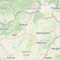
Distance Map Between Braila and Zalau
Braila, Romania ↔ Zalau, Romania = 271 miles = 436 km.


How far is it between Brăila and Zalău
Braila is located in Romania with (45.2667,27.9833) coordinates and Zalau is located in Romania with (47.2,23.05) coordinates. The calculated flying distance from Braila to Zalau is equal to 271 miles which is equal to 436 km.
If you want to go by car, the driving distance between Braila and Zalau is 631.5 km. If you ride your car with an average speed of 112 kilometers/hour (70 miles/h), travel time will be 05 hours 38 minutes. Please check the avg. speed travel time table on the right for various options.
Difference between fly and go by a car is 196 km.
| City/Place | Latitude and Longitude | GPS Coordinates |
|---|---|---|
| Braila | 45.2667, 27.9833 | 45° 16´ 0.0120'' N 27° 58´ 59.9880'' E |
| Zalau | 47.2, 23.05 | 47° 12´ 0.0000'' N 23° 3´ 0.0000'' E |
Estimated Travel Time Between Brăila and Zalău
| Average Speed | Travel Time |
|---|---|
| 30 mph (48 km/h) | 13 hours 09 minutes |
| 40 mph (64 km/h) | 09 hours 52 minutes |
| 50 mph (80 km/h) | 07 hours 53 minutes |
| 60 mph (97 km/h) | 06 hours 30 minutes |
| 70 mph (112 km/h) | 05 hours 38 minutes |
| 75 mph (120 km/h) | 05 hours 15 minutes |
Related Distances from Braila
| Cities | Distance |
|---|---|
| Braila to Bucharest | 221 km |
| Braila to Galati | 31 km |
| Braila to Constanta | 202 km |
| Braila to Tulcea | 100 km |
| Braila to Iasi | 248 km |
Related Distances to Zalau
| Cities | Distance |
|---|---|
| Cluj Napoca to Zalau | 87 km |
| Bucharest to Zalau | 551 km |
| Oradea to Zalau | 117 km |
| Baia Mare 2 to Zalau | 83 km |
| Brasov to Zalau | 372 km |