Distance from Bridgeton to Cherry Hill
Distance between Bridgeton and Cherry Hill is 59 kilometers (37 miles).
Driving distance from Bridgeton to Cherry Hill is 66 kilometers (41 miles).
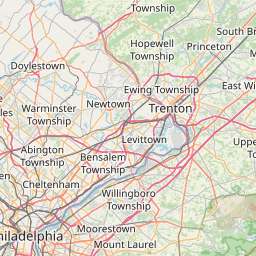
Distance Map Between Bridgeton and Cherry Hill
Bridgeton, Trenton, United States ↔ Cherry Hill, Trenton, United States = 37 miles = 59 km.


How far is it between Bridgeton and Cherry Hill
Bridgeton is located in United States with (39.4273,-75.2341) coordinates and Cherry Hill is located in United States with (39.9348,-75.0307) coordinates. The calculated flying distance from Bridgeton to Cherry Hill is equal to 37 miles which is equal to 59 km.
If you want to go by car, the driving distance between Bridgeton and Cherry Hill is 65.79 km. If you ride your car with an average speed of 112 kilometers/hour (70 miles/h), travel time will be 00 hours 35 minutes. Please check the avg. speed travel time table on the right for various options.
Difference between fly and go by a car is 7 km.
| City/Place | Latitude and Longitude | GPS Coordinates |
|---|---|---|
| Bridgeton | 39.4273, -75.2341 | 39° 25´ 38.4240'' N 75° 14´ 2.6880'' W |
| Cherry Hill | 39.9348, -75.0307 | 39° 56´ 5.4240'' N 75° 1´ 50.6280'' W |
Estimated Travel Time Between Bridgeton and Cherry Hill
| Average Speed | Travel Time |
|---|---|
| 30 mph (48 km/h) | 01 hours 22 minutes |
| 40 mph (64 km/h) | 01 hours 01 minutes |
| 50 mph (80 km/h) | 00 hours 49 minutes |
| 60 mph (97 km/h) | 00 hours 40 minutes |
| 70 mph (112 km/h) | 00 hours 35 minutes |
| 75 mph (120 km/h) | 00 hours 32 minutes |
Related Distances from Bridgeton
| Cities | Distance |
|---|---|
| Bridgeton to Atlantic City | 76 km |
| Bridgeton to Camden | 61 km |
| Bridgeton to Glassboro | 33 km |
| Bridgeton to Cherry Hill | 66 km |
| Bridgeton to Jackson 3 | 57 km |
Related Distances to Cherry Hill
| Cities | Distance |
|---|---|
| Mount Laurel to Cherry Hill | 15 km |
| Jersey City to Cherry Hill | 131 km |
| Willingboro to Cherry Hill | 26 km |
| Garfield to Cherry Hill | 148 km |
| Asbury Park to Cherry Hill | 108 km |