Distance from Bundaberg to Nerang
Distance between Bundaberg and Nerang is 361 kilometers (224 miles).
Driving distance from Bundaberg to Nerang is 433 kilometers (269 miles).
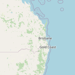
Distance Map Between Bundaberg and Nerang
Bundaberg, Brisbane, Australia ↔ Nerang, Brisbane, Australia = 224 miles = 361 km.


How far is it between Bundaberg and Nerang
Bundaberg is located in Australia with (-24.8662,152.3479) coordinates and Nerang is located in Australia with (-27.9894,153.3363) coordinates. The calculated flying distance from Bundaberg to Nerang is equal to 224 miles which is equal to 361 km.
If you want to go by car, the driving distance between Bundaberg and Nerang is 432.83 km. If you ride your car with an average speed of 112 kilometers/hour (70 miles/h), travel time will be 03 hours 51 minutes. Please check the avg. speed travel time table on the right for various options.
Difference between fly and go by a car is 72 km.
| City/Place | Latitude and Longitude | GPS Coordinates |
|---|---|---|
| Bundaberg | -24.8662, 152.3479 | 24° 51´ 58.3560'' S 152° 20´ 52.4400'' E |
| Nerang | -27.9894, 153.3363 | 27° 59´ 21.8760'' S 153° 20´ 10.7880'' E |
Estimated Travel Time Between Bundaberg and Nerang
| Average Speed | Travel Time |
|---|---|
| 30 mph (48 km/h) | 09 hours 01 minutes |
| 40 mph (64 km/h) | 06 hours 45 minutes |
| 50 mph (80 km/h) | 05 hours 24 minutes |
| 60 mph (97 km/h) | 04 hours 27 minutes |
| 70 mph (112 km/h) | 03 hours 51 minutes |
| 75 mph (120 km/h) | 03 hours 36 minutes |
Related Distances from Bundaberg
| Cities | Distance |
|---|---|
| Bundaberg to Rockhampton | 287 km |
| Bundaberg to Gladstone | 186 km |
| Bundaberg to Mackay | 620 km |
| Bundaberg to Townsville | 1005 km |
| Bundaberg to Maryborough | 112 km |
Related Distances to Nerang
| Cities | Distance |
|---|---|
| Gold Coast to Nerang | 11 km |
| Logan City to Nerang | 52 km |
| Caloundra to Nerang | 162 km |
| South Brisbane to Nerang | 69 km |
| Bundaberg to Nerang | 433 km |