Distance from Colombo to Attur
Distance between Colombo and Attur is 536 kilometers (333 miles).
Driving distance from Colombo to Attur is 1104 kilometers (686 miles).
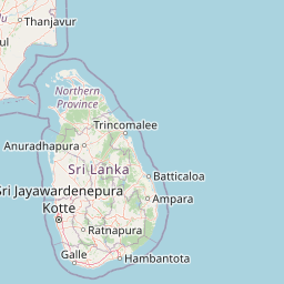
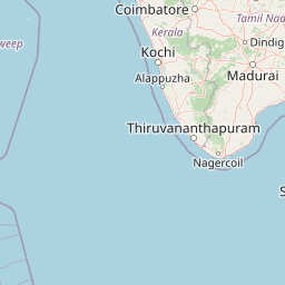
Distance Map Between Colombo and Attur
Colombo, Sri Lanka ↔ Attur, Chennai, India = 333 miles = 536 km.


How far is it between Colombo and Attur
Colombo is located in Sri Lanka with (6.9319,79.8478) coordinates and Attur is located in India with (11.5941,78.6014) coordinates. The calculated flying distance from Colombo to Attur is equal to 333 miles which is equal to 536 km.
If you want to go by car, the driving distance between Colombo and Attur is 1103.95 km. If you ride your car with an average speed of 112 kilometers/hour (70 miles/h), travel time will be 09 hours 51 minutes. Please check the avg. speed travel time table on the right for various options.
Difference between fly and go by a car is 568 km.
| City/Place | Latitude and Longitude | GPS Coordinates |
|---|---|---|
| Colombo | 6.9319, 79.8478 | 6° 55´ 54.9840'' N 79° 50´ 52.0080'' E |
| Attur | 11.5941, 78.6014 | 11° 35´ 38.9040'' N 78° 36´ 5.1480'' E |
Estimated Travel Time Between Colombo and Attur
| Average Speed | Travel Time |
|---|---|
| 30 mph (48 km/h) | 22 hours 59 minutes |
| 40 mph (64 km/h) | 17 hours 14 minutes |
| 50 mph (80 km/h) | 13 hours 47 minutes |
| 60 mph (97 km/h) | 11 hours 22 minutes |
| 70 mph (112 km/h) | 09 hours 51 minutes |
| 75 mph (120 km/h) | 09 hours 11 minutes |
Related Distances from Colombo
| Cities | Distance |
|---|---|
| Colombo to Chennai | 1208 km |
| Colombo to Bangalore | 1364 km |
| Colombo to Mumbai | 2352 km |
| Colombo to Thiruvananthapuram | 1418 km |
| Colombo to Madurai | 1160 km |