Distance from Damanhur to Sohag
Distance between Damanhur and Sohag is 512 kilometers (318 miles).
Driving distance from Damanhur to Sohag is 674 kilometers (419 miles).
Distance Map Between Damanhur and Sohag
Damanhur, Egypt ↔ Sohag, Egypt = 318 miles = 512 km.


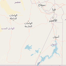


How far is it between Damanhūr and Sohag
Damanhur is located in Egypt with (31.0341,30.4682) coordinates and Sohag is located in Egypt with (26.557,31.6948) coordinates. The calculated flying distance from Damanhur to Sohag is equal to 318 miles which is equal to 512 km.
If you want to go by car, the driving distance between Damanhur and Sohag is 674.41 km. If you ride your car with an average speed of 112 kilometers/hour (70 miles/h), travel time will be 06 hours 01 minutes. Please check the avg. speed travel time table on the right for various options.
Difference between fly and go by a car is 162 km.
| City/Place | Latitude and Longitude | GPS Coordinates |
|---|---|---|
| Damanhur | 31.0341, 30.4682 | 31° 2´ 2.6880'' N 30° 28´ 5.6280'' E |
| Sohag | 26.557, 31.6948 | 26° 33´ 25.0200'' N 31° 41´ 41.2080'' E |
Estimated Travel Time Between Damanhūr and Sohag
| Average Speed | Travel Time |
|---|---|
| 30 mph (48 km/h) | 14 hours 03 minutes |
| 40 mph (64 km/h) | 10 hours 32 minutes |
| 50 mph (80 km/h) | 08 hours 25 minutes |
| 60 mph (97 km/h) | 06 hours 57 minutes |
| 70 mph (112 km/h) | 06 hours 01 minutes |
| 75 mph (120 km/h) | 05 hours 37 minutes |
Related Distances from Damanhur
| Cities | Distance |
|---|---|
| Damanhur to Damietta | 189 km |
| Damanhur to Shibin Al Kawm | 86 km |
| Damanhur to Tanda | 65 km |
| Damanhur to Qina | 741 km |
| Damanhur to Mersa Matruh | 349 km |
Related Distances to Sohag
| Cities | Distance |
|---|---|
| Cairo to Sohag | 463 km |
| Luxor to Sohag | 221 km |
| Hurghada to Sohag | 359 km |
| Asyut to Sohag | 107 km |
| Alexandria to Sohag | 719 km |