Distance from Dhar to Jhabua
Distance between Dhar and Jhabua is 75 kilometers (47 miles).
Driving distance from Dhar to Jhabua is 87 kilometers (54 miles).
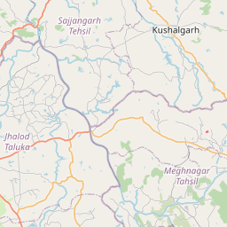
Distance Map Between Dhar and Jhabua
Dhar, Bhopal, India ↔ Jhabua, Bhopal, India = 47 miles = 75 km.


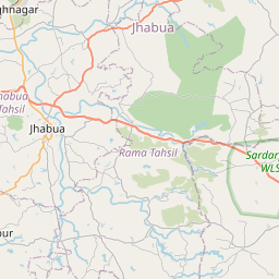


Leaflet | © OpenStreetMap
How far is it between Dhār and Jhābua
Dhar is located in India with (22.5937,75.2977) coordinates and Jhabua is located in India with (22.7682,74.5914) coordinates. The calculated flying distance from Dhar to Jhabua is equal to 47 miles which is equal to 75 km.
If you want to go by car, the driving distance between Dhar and Jhabua is 86.74 km. If you ride your car with an average speed of 112 kilometers/hour (70 miles/h), travel time will be 00 hours 46 minutes. Please check the avg. speed travel time table on the right for various options.
Difference between fly and go by a car is 12 km.
| City/Place | Latitude and Longitude | GPS Coordinates |
|---|---|---|
| Dhar | 22.5937, 75.2977 | 22° 35´ 37.4280'' N 75° 17´ 51.8640'' E |
| Jhabua | 22.7682, 74.5914 | 22° 46´ 5.4840'' N 74° 35´ 29.1480'' E |
Estimated Travel Time Between Dhār and Jhābua
| Average Speed | Travel Time |
|---|---|
| 30 mph (48 km/h) | 01 hours 48 minutes |
| 40 mph (64 km/h) | 01 hours 21 minutes |
| 50 mph (80 km/h) | 01 hours 05 minutes |
| 60 mph (97 km/h) | 00 hours 53 minutes |
| 70 mph (112 km/h) | 00 hours 46 minutes |
| 75 mph (120 km/h) | 00 hours 43 minutes |
Dhar, Bhopal, India
Related Distances from Dhar
| Cities | Distance |
|---|---|
| Dhar to Manawar | 73 km |
| Dhar to Kukshi | 111 km |
| Dhar to Mandu | 35 km |
| Dhar to Nagda | 120 km |
| Dhar to Maheshwar | 72 km |
Jhabua, Bhopal, India
Related Distances to Jhabua
| Cities | Distance |
|---|---|
| Badnawar to Jhabua | 98 km |
| Indore to Jhabua | 151 km |
| Barwani to Jhabua | 119 km |
| Jaora to Jhabua | 139 km |
| Dhar to Jhabua | 87 km |