Distance from Dhule to Manmad
Distance between Dhule and Manmad is 80 kilometers (50 miles).
Driving distance from Dhule to Manmad is 88 kilometers (55 miles).
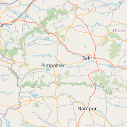
Distance Map Between Dhule and Manmad
Dhule, Mumbai, India ↔ Manmad, Mumbai, India = 50 miles = 80 km.


How far is it between Dhule and Manmād
Dhule is located in India with (20.9025,74.7774) coordinates and Manmad is located in India with (20.2525,74.4412) coordinates. The calculated flying distance from Dhule to Manmad is equal to 50 miles which is equal to 80 km.
If you want to go by car, the driving distance between Dhule and Manmad is 87.88 km. If you ride your car with an average speed of 112 kilometers/hour (70 miles/h), travel time will be 00 hours 47 minutes. Please check the avg. speed travel time table on the right for various options.
Difference between fly and go by a car is 8 km.
| City/Place | Latitude and Longitude | GPS Coordinates |
|---|---|---|
| Dhule | 20.9025, 74.7774 | 20° 54´ 9.0360'' N 74° 46´ 38.4600'' E |
| Manmad | 20.2525, 74.4412 | 20° 15´ 8.8920'' N 74° 26´ 28.1400'' E |
Estimated Travel Time Between Dhule and Manmād
| Average Speed | Travel Time |
|---|---|
| 30 mph (48 km/h) | 01 hours 49 minutes |
| 40 mph (64 km/h) | 01 hours 22 minutes |
| 50 mph (80 km/h) | 01 hours 05 minutes |
| 60 mph (97 km/h) | 00 hours 54 minutes |
| 70 mph (112 km/h) | 00 hours 47 minutes |
| 75 mph (120 km/h) | 00 hours 43 minutes |
Related Distances from Dhule
| Cities | Distance |
|---|---|
| Dhule to Shirpur | 55 km |
| Dhule to Parola | 37 km |
| Dhule to Shahada | 86 km |
| Dhule to Dondaicha | 57 km |
| Dhule to Nandgaon | 87 km |
Related Distances to Manmad
| Cities | Distance |
|---|---|
| Kannad to Manmad | 101 km |
| Malegaon to Manmad | 37 km |
| Chakan to Manmad | 203 km |
| Dombivli to Manmad | 230 km |
| Aurangabad to Manmad | 118 km |