Distance from Doba to Mao
Distance between Doba and Mao is 631 kilometers (392 miles).
Driving distance from Doba to Mao is 808 kilometers (502 miles).
Distance Map Between Doba and Mao
Doba, Chad ↔ Mao, Chad = 392 miles = 631 km.


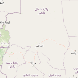


Leaflet | © OpenStreetMap
How far is it between Doba and Mao
Doba is located in Chad with (8.65,16.85) coordinates and Mao is located in Chad with (14.1212,15.3103) coordinates. The calculated flying distance from Doba to Mao is equal to 392 miles which is equal to 631 km.
If you want to go by car, the driving distance between Doba and Mao is 808.34 km. If you ride your car with an average speed of 112 kilometers/hour (70 miles/h), travel time will be 07 hours 13 minutes. Please check the avg. speed travel time table on the right for various options.
Difference between fly and go by a car is 177 km.
| City/Place | Latitude and Longitude | GPS Coordinates |
|---|---|---|
| Doba | 8.65, 16.85 | 8° 39´ 0.0000'' N 16° 51´ 0.0000'' E |
| Mao | 14.1212, 15.3103 | 14° 7´ 16.1760'' N 15° 18´ 37.0800'' E |
Estimated Travel Time Between Doba and Mao
| Average Speed | Travel Time |
|---|---|
| 30 mph (48 km/h) | 16 hours 50 minutes |
| 40 mph (64 km/h) | 12 hours 37 minutes |
| 50 mph (80 km/h) | 10 hours 06 minutes |
| 60 mph (97 km/h) | 08 hours 20 minutes |
| 70 mph (112 km/h) | 07 hours 13 minutes |
| 75 mph (120 km/h) | 06 hours 44 minutes |
Doba, Chad
Related Distances from Doba
| Cities | Distance |
|---|---|
| Doba to N Djamena | 497 km |
| Doba to Moundou | 108 km |
| Doba to Koumra | 90 km |
| Doba to Lai | 111 km |
| Doba to Pala | 295 km |
Mao, Chad
Related Distances to Mao
| Cities | Distance |
|---|---|
| Ati to Mao 3 | 592 km |
| Lai to Mao 3 | 696 km |
| Bongor to Mao 3 | 550 km |
| Doba to Mao 3 | 808 km |
| Koumra to Mao 3 | 856 km |