Distance from Dover to Derry
Distance between Dover and Derry is 51 kilometers (32 miles).
Driving distance from Dover to Derry is 60 kilometers (37 miles).
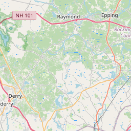
Distance Map Between Dover and Derry
Dover, Concord, United States ↔ Derry, Concord, United States = 32 miles = 51 km.


How far is it between Dover and Derry
Dover is located in United States with (43.1979,-70.8737) coordinates and Derry is located in United States with (42.8806,-71.3273) coordinates. The calculated flying distance from Dover to Derry is equal to 32 miles which is equal to 51 km.
If you want to go by car, the driving distance between Dover and Derry is 59.76 km. If you ride your car with an average speed of 112 kilometers/hour (70 miles/h), travel time will be 00 hours 32 minutes. Please check the avg. speed travel time table on the right for various options.
Difference between fly and go by a car is 9 km.
| City/Place | Latitude and Longitude | GPS Coordinates |
|---|---|---|
| Dover | 43.1979, -70.8737 | 43° 11´ 52.2960'' N 70° 52´ 25.2120'' W |
| Derry | 42.8806, -71.3273 | 42° 52´ 50.3040'' N 71° 19´ 38.2440'' W |
Estimated Travel Time Between Dover and Derry
| Average Speed | Travel Time |
|---|---|
| 30 mph (48 km/h) | 01 hours 14 minutes |
| 40 mph (64 km/h) | 00 hours 56 minutes |
| 50 mph (80 km/h) | 00 hours 44 minutes |
| 60 mph (97 km/h) | 00 hours 36 minutes |
| 70 mph (112 km/h) | 00 hours 32 minutes |
| 75 mph (120 km/h) | 00 hours 29 minutes |
Related Distances from Dover
| Cities | Distance |
|---|---|
| Dover 2 to Keene | 148 km |
| Dover 2 to Bedford 3 | 72 km |
| Dover 2 to Derry 2 | 60 km |
| Dover 2 to Derry Village | 58 km |
| Dover 2 to East Concord | 62 km |
Related Distances to Derry
| Cities | Distance |
|---|---|
| Nashua to Derry 2 | 20 km |
| Manchester 2 to Derry 2 | 21 km |
| Portsmouth 3 to Derry 2 | 66 km |
| East Concord to Derry 2 | 50 km |
| Salem 4 to Derry 2 | 19 km |