Distance from Dushanbe to Kabul
Distance between Dushanbe and Kabul is 447 kilometers (278 miles).
Driving distance from Dushanbe to Kabul is 576 kilometers (358 miles).
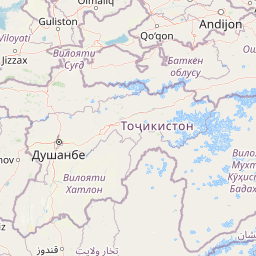
Distance Map Between Dushanbe and Kabul
Dushanbe, Tajikistan ↔ Kabul, Afghanistan = 278 miles = 447 km.


How far is it between Dushanbe and Kabul
Dushanbe is located in Tajikistan with (38.5358,68.7791) coordinates and Kabul is located in Afghanistan with (34.5281,69.1723) coordinates. The calculated flying distance from Dushanbe to Kabul is equal to 278 miles which is equal to 447 km.
If you want to go by car, the driving distance between Dushanbe and Kabul is 575.91 km. If you ride your car with an average speed of 112 kilometers/hour (70 miles/h), travel time will be 05 hours 08 minutes. Please check the avg. speed travel time table on the right for various options.
Difference between fly and go by a car is 129 km.
| City/Place | Latitude and Longitude | GPS Coordinates |
|---|---|---|
| Dushanbe | 38.5358, 68.7791 | 38° 32´ 8.7000'' N 68° 46´ 44.5800'' E |
| Kabul | 34.5281, 69.1723 | 34° 31´ 41.2680'' N 69° 10´ 20.3880'' E |
Estimated Travel Time Between Dushanbe and Kabul
| Average Speed | Travel Time |
|---|---|
| 30 mph (48 km/h) | 11 hours 59 minutes |
| 40 mph (64 km/h) | 08 hours 59 minutes |
| 50 mph (80 km/h) | 07 hours 11 minutes |
| 60 mph (97 km/h) | 05 hours 56 minutes |
| 70 mph (112 km/h) | 05 hours 08 minutes |
| 75 mph (120 km/h) | 04 hours 47 minutes |
Related Distances to Kabul
| Cities | Distance |
|---|---|
| Dushanbe to Kabul | 576 km |
| Khujand to Kabul | 877 km |
| Farkhor to Kabul | 524 km |
| Qurghonteppa to Kabul | 485 km |
| Khorugh to Kabul | 616 km |