Distance from East Pensacola Heights to Boynton Beach
Distance between East Pensacola Heights and Boynton Beach is 819 kilometers (509 miles).
Distance Map Between East Pensacola Heights and Boynton Beach
East Pensacola Heights, Tallahassee, United States ↔ Boynton Beach, Tallahassee, United States = 509 miles = 819 km.


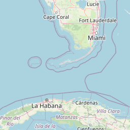


Leaflet | © OpenStreetMap
How far is it between East Pensacola Heights and Boynton Beach
East Pensacola Heights is located in United States with (30.4288,-87.18) coordinates and Boynton Beach is located in United States with (26.5254,-80.0664) coordinates. The calculated flying distance from East Pensacola Heights to Boynton Beach is equal to 509 miles which is equal to 819 km.
| City/Place | Latitude and Longitude | GPS Coordinates |
|---|---|---|
| East Pensacola Heights | 30.4288, -87.18 | 30° 25´ 43.7160'' N 87° 10´ 47.8920'' W |
| Boynton Beach | 26.5254, -80.0664 | 26° 31´ 31.2600'' N 80° 3´ 59.1480'' W |
East Pensacola Heights, Tallahassee, United States
Related Distances from East Pensacola Heights
Boynton Beach, Tallahassee, United States
Related Distances to Boynton Beach
| Cities | Distance |
|---|---|
| Miami to Boynton Beach | 91 km |
| Fort Lauderdale to Boynton Beach | 52 km |
| West Palm Beach to Boynton Beach | 25 km |
| Jupiter to Boynton Beach | 48 km |
| Delray Beach to Boynton Beach | 10 km |