Distance from Fair Lawn to Vineland
Distance between Fair Lawn and Vineland is 179 kilometers (111 miles).
Driving distance from Fair Lawn to Vineland is 216 kilometers (134 miles).
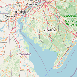
Distance Map Between Fair Lawn and Vineland
Fair Lawn, Trenton, United States ↔ Vineland, Trenton, United States = 111 miles = 179 km.


How far is it between Fair Lawn and Vineland
Fair Lawn is located in United States with (40.9404,-74.1318) coordinates and Vineland is located in United States with (39.4862,-75.0257) coordinates. The calculated flying distance from Fair Lawn to Vineland is equal to 111 miles which is equal to 179 km.
If you want to go by car, the driving distance between Fair Lawn and Vineland is 216.07 km. If you ride your car with an average speed of 112 kilometers/hour (70 miles/h), travel time will be 01 hours 55 minutes. Please check the avg. speed travel time table on the right for various options.
Difference between fly and go by a car is 37 km.
| City/Place | Latitude and Longitude | GPS Coordinates |
|---|---|---|
| Fair Lawn | 40.9404, -74.1318 | 40° 56´ 25.3680'' N 74° 7´ 54.5160'' W |
| Vineland | 39.4862, -75.0257 | 39° 29´ 10.4280'' N 75° 1´ 32.6280'' W |
Estimated Travel Time Between Fair Lawn and Vineland
| Average Speed | Travel Time |
|---|---|
| 30 mph (48 km/h) | 04 hours 30 minutes |
| 40 mph (64 km/h) | 03 hours 22 minutes |
| 50 mph (80 km/h) | 02 hours 42 minutes |
| 60 mph (97 km/h) | 02 hours 13 minutes |
| 70 mph (112 km/h) | 01 hours 55 minutes |
| 75 mph (120 km/h) | 01 hours 48 minutes |
Related Distances from Fair Lawn
| Cities | Distance |
|---|---|
| Fair Lawn to Lindenwold | 167 km |
| Fair Lawn to Toms River | 134 km |
| Fair Lawn to Belleville 3 | 20 km |
| Fair Lawn to Elmwood Park 2 | 5 km |
| Fair Lawn to Bergenfield | 15 km |
Related Distances to Vineland
| Cities | Distance |
|---|---|
| Newark to Vineland | 184 km |
| Union to Vineland | 181 km |
| Willingboro to Vineland | 85 km |
| Kearny to Vineland | 192 km |
| North Bergen to Vineland | 199 km |