Distance from Fort Wayne to Greenwood
Distance between Fort Wayne and Greenwood is 188 kilometers (117 miles).
Driving distance from Fort Wayne to Greenwood is 223 kilometers (139 miles).
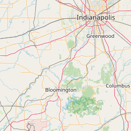
Distance Map Between Fort Wayne and Greenwood
Fort Wayne, Indianapolis, United States ↔ Greenwood, Indianapolis, United States = 117 miles = 188 km.


How far is it between Fort Wayne and Greenwood
Fort Wayne is located in United States with (41.1306,-85.1289) coordinates and Greenwood is located in United States with (39.6137,-86.1067) coordinates. The calculated flying distance from Fort Wayne to Greenwood is equal to 117 miles which is equal to 188 km.
If you want to go by car, the driving distance between Fort Wayne and Greenwood is 223.48 km. If you ride your car with an average speed of 112 kilometers/hour (70 miles/h), travel time will be 01 hours 59 minutes. Please check the avg. speed travel time table on the right for various options.
Difference between fly and go by a car is 35 km.
| City/Place | Latitude and Longitude | GPS Coordinates |
|---|---|---|
| Fort Wayne | 41.1306, -85.1289 | 41° 7´ 50.1600'' N 85° 7´ 43.8960'' W |
| Greenwood | 39.6137, -86.1067 | 39° 36´ 49.1760'' N 86° 6´ 23.9400'' W |
Estimated Travel Time Between Fort Wayne and Greenwood
| Average Speed | Travel Time |
|---|---|
| 30 mph (48 km/h) | 04 hours 39 minutes |
| 40 mph (64 km/h) | 03 hours 29 minutes |
| 50 mph (80 km/h) | 02 hours 47 minutes |
| 60 mph (97 km/h) | 02 hours 18 minutes |
| 70 mph (112 km/h) | 01 hours 59 minutes |
| 75 mph (120 km/h) | 01 hours 51 minutes |
Related Distances from Fort Wayne
| Cities | Distance |
|---|---|
| Fort Wayne to Anderson | 139 km |
| Fort Wayne to Bloomington 2 | 288 km |
| Fort Wayne to Broad Ripple | 193 km |
| Fort Wayne to Brownsburg | 230 km |
| Fort Wayne to Carmel | 195 km |
| Fort Wayne to Chicago | 257 km |
| Fort Wayne to Clarksville 2 | 378 km |
| Fort Wayne to Columbus 3 | 274 km |
| Fort Wayne to Crawfordsville | 261 km |
| Fort Wayne to Crown Point | 201 km |
Related Distances to Greenwood
| Cities | Distance |
|---|---|
| Vicksburg to Greenwood 3 | 161 km |
| Laporte to Greenwood | 267 km |
| Shelbyville 2 to Greenwood | 40 km |
| Griffith to Greenwood | 265 km |
| Oxford 4 to Greenwood 3 | 128 km |
| Logansport to Greenwood | 154 km |
| Lawrence 3 to Greenwood | 34 km |
| South Bend to Greenwood | 253 km |
| Franklin 4 to Greenwood | 16 km |
| Highland 2 to Greenwood | 274 km |