Distance from Gillette to Laramie
Distance between Gillette and Laramie is 331 kilometers (206 miles).
Driving distance from Gillette to Laramie is 405 kilometers (251 miles).
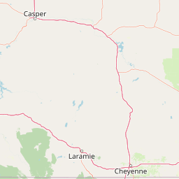
Distance Map Between Gillette and Laramie
Gillette, Cheyenne, United States ↔ Laramie, Cheyenne, United States = 206 miles = 331 km.


How far is it between Gillette and Laramie
Gillette is located in United States with (44.2911,-105.5022) coordinates and Laramie is located in United States with (41.3114,-105.5911) coordinates. The calculated flying distance from Gillette to Laramie is equal to 206 miles which is equal to 331 km.
If you want to go by car, the driving distance between Gillette and Laramie is 404.71 km. If you ride your car with an average speed of 112 kilometers/hour (70 miles/h), travel time will be 03 hours 36 minutes. Please check the avg. speed travel time table on the right for various options.
Difference between fly and go by a car is 74 km.
| City/Place | Latitude and Longitude | GPS Coordinates |
|---|---|---|
| Gillette | 44.2911, -105.5022 | 44° 17´ 27.9240'' N 105° 30´ 7.9920'' W |
| Laramie | 41.3114, -105.5911 | 41° 18´ 40.9320'' N 105° 35´ 27.9600'' W |
Estimated Travel Time Between Gillette and Laramie
| Average Speed | Travel Time |
|---|---|
| 30 mph (48 km/h) | 08 hours 25 minutes |
| 40 mph (64 km/h) | 06 hours 19 minutes |
| 50 mph (80 km/h) | 05 hours 03 minutes |
| 60 mph (97 km/h) | 04 hours 10 minutes |
| 70 mph (112 km/h) | 03 hours 36 minutes |
| 75 mph (120 km/h) | 03 hours 22 minutes |
Related Distances from Gillette
| Cities | Distance |
|---|---|
| Gillette to Casper | 203 km |
| Gillette to Laramie | 405 km |
| Gillette to Rock Springs | 561 km |
Related Distances to Laramie
| Cities | Distance |
|---|---|
| Casper to Laramie | 240 km |
| Sheridan to Laramie | 477 km |
| Gillette to Laramie | 405 km |
| Rock Springs to Laramie | 334 km |