Distance from Gosport to Swindon
Distance between Gosport and Swindon is 96 kilometers (60 miles).
Driving distance from Gosport to Swindon is 128 kilometers (80 miles).
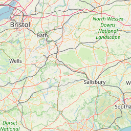
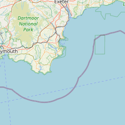
Distance Map Between Gosport and Swindon
Gosport, London, United Kingdom ↔ Swindon, London, United Kingdom = 60 miles = 96 km.


How far is it between Gosport and Swindon
Gosport is located in United Kingdom with (50.7951,-1.129) coordinates and Swindon is located in United Kingdom with (51.558,-1.7812) coordinates. The calculated flying distance from Gosport to Swindon is equal to 60 miles which is equal to 96 km.
If you want to go by car, the driving distance between Gosport and Swindon is 128.3 km. If you ride your car with an average speed of 112 kilometers/hour (70 miles/h), travel time will be 01 hours 08 minutes. Please check the avg. speed travel time table on the right for various options.
Difference between fly and go by a car is 32 km.
| City/Place | Latitude and Longitude | GPS Coordinates |
|---|---|---|
| Gosport | 50.7951, -1.129 | 50° 47´ 42.3240'' N 1° 7´ 44.4720'' W |
| Swindon | 51.558, -1.7812 | 51° 33´ 28.6920'' N 1° 46´ 52.1760'' W |
Estimated Travel Time Between Gosport and Swindon
| Average Speed | Travel Time |
|---|---|
| 30 mph (48 km/h) | 02 hours 40 minutes |
| 40 mph (64 km/h) | 02 hours 00 minutes |
| 50 mph (80 km/h) | 01 hours 36 minutes |
| 60 mph (97 km/h) | 01 hours 19 minutes |
| 70 mph (112 km/h) | 01 hours 08 minutes |
| 75 mph (120 km/h) | 01 hours 04 minutes |
Related Distances from Gosport
| Cities | Distance |
|---|---|
| Gosport to Portsmouth | 21 km |
| Gosport to Southampton | 30 km |
| Gosport to Newcastle Upon Tyne | 561 km |
| Gosport to City Of London | 135 km |
| Gosport to Oxford | 133 km |
Related Distances to Swindon
| Cities | Distance |
|---|---|
| London to Swindon | 130 km |
| Birmingham to Swindon | 134 km |
| Bristol to Swindon | 65 km |
| Reading to Swindon | 66 km |
| Oxford to Swindon | 54 km |