Distance from Haltern to Stolberg
Distance between Haltern and Stolberg is 127 kilometers (79 miles).
Driving distance from Haltern to Stolberg is 169 kilometers (105 miles).
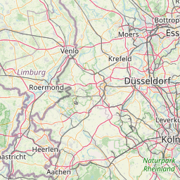
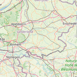
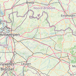
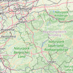
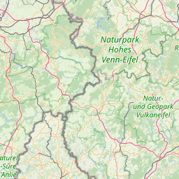
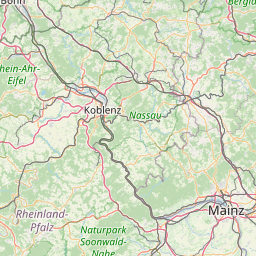
Distance Map Between Haltern and Stolberg
Haltern, Dusseldorf, Germany ↔ Stolberg, Dusseldorf, Germany = 79 miles = 127 km.


How far is it between Haltern and Stolberg
Haltern is located in Germany with (51.743,7.1816) coordinates and Stolberg is located in Germany with (50.7737,6.226) coordinates. The calculated flying distance from Haltern to Stolberg is equal to 79 miles which is equal to 127 km.
If you want to go by car, the driving distance between Haltern and Stolberg is 169.32 km. If you ride your car with an average speed of 112 kilometers/hour (70 miles/h), travel time will be 01 hours 30 minutes. Please check the avg. speed travel time table on the right for various options.
Difference between fly and go by a car is 42 km.
| City/Place | Latitude and Longitude | GPS Coordinates |
|---|---|---|
| Haltern | 51.743, 7.1816 | 51° 44´ 34.6920'' N 7° 10´ 53.8680'' E |
| Stolberg | 50.7737, 6.226 | 50° 46´ 25.2480'' N 6° 13´ 33.4200'' E |
Estimated Travel Time Between Haltern and Stolberg
| Average Speed | Travel Time |
|---|---|
| 30 mph (48 km/h) | 03 hours 31 minutes |
| 40 mph (64 km/h) | 02 hours 38 minutes |
| 50 mph (80 km/h) | 02 hours 06 minutes |
| 60 mph (97 km/h) | 01 hours 44 minutes |
| 70 mph (112 km/h) | 01 hours 30 minutes |
| 75 mph (120 km/h) | 01 hours 24 minutes |
Related Distances from Haltern
| Cities | Distance |
|---|---|
| Haltern to Hamm | 76 km |
| Haltern to Hattingen | 51 km |
| Haltern to Herford | 157 km |
| Haltern to Herne | 29 km |
| Haltern to Herten | 20 km |
| Haltern to Hilden | 87 km |
| Haltern to Hurth | 123 km |
| Haltern to Iserlohn | 79 km |
| Haltern to Kerpen | 132 km |
| Haltern to Koeln | 120 km |
Related Distances to Stolberg
| Cities | Distance |
|---|---|
| Bonn to Stolberg | 85 km |
| Muenster to Stolberg | 205 km |
| Krefeld to Stolberg | 84 km |
| Aachen to Stolberg | 13 km |
| Solingen to Stolberg | 93 km |
| Dortmund to Stolberg | 150 km |
| Recklinghausen to Stolberg | 153 km |
| Siegburg to Stolberg | 92 km |
| Dueren to Stolberg | 28 km |
| Alsdorf to Stolberg | 18 km |