Distance from Ihosy to Maevatanana
Distance between Ihosy and Maevatanana is 611 kilometers (380 miles).
Driving distance from Ihosy to Maevatanana is 896 kilometers (557 miles).
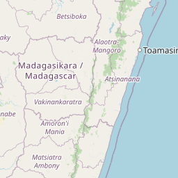
Distance Map Between Ihosy and Maevatanana
Ihosy, Madagascar ↔ Maevatanana, Madagascar = 380 miles = 611 km.


How far is it between Ihosy and Maevatanana
Ihosy is located in Madagascar with (-22.4029,46.1258) coordinates and Maevatanana is located in Madagascar with (-16.95,46.8333) coordinates. The calculated flying distance from Ihosy to Maevatanana is equal to 380 miles which is equal to 611 km.
If you want to go by car, the driving distance between Ihosy and Maevatanana is 896.41 km. If you ride your car with an average speed of 112 kilometers/hour (70 miles/h), travel time will be 08 hours 00 minutes. Please check the avg. speed travel time table on the right for various options.
Difference between fly and go by a car is 285 km.
| City/Place | Latitude and Longitude | GPS Coordinates |
|---|---|---|
| Ihosy | -22.4029, 46.1258 | 22° 24´ 10.5480'' S 46° 7´ 32.7360'' E |
| Maevatanana | -16.95, 46.8333 | 16° 56´ 60.0000'' S 46° 49´ 59.9880'' E |
Estimated Travel Time Between Ihosy and Maevatanana
| Average Speed | Travel Time |
|---|---|
| 30 mph (48 km/h) | 18 hours 40 minutes |
| 40 mph (64 km/h) | 14 hours 00 minutes |
| 50 mph (80 km/h) | 11 hours 12 minutes |
| 60 mph (97 km/h) | 09 hours 14 minutes |
| 70 mph (112 km/h) | 08 hours 00 minutes |
| 75 mph (120 km/h) | 07 hours 28 minutes |
Related Distances from Ihosy
| Cities | Distance |
|---|---|
| Ihosy to Fort Dauphin | 508 km |
| Ihosy to Maevatanana | 896 km |
| Ihosy to Mahajanga | 1150 km |
| Ihosy to Manakara | 363 km |
| Ihosy to Morondava | 647 km |
| Ihosy to Sambava | 1868 km |
| Ihosy to Toamasina | 939 km |
| Ihosy to Toliara | 327 km |
| Ihosy to Tsiroanomandidy | 698 km |
Related Distances to Maevatanana
| Cities | Distance |
|---|---|
| Antananarivo to Maevatanana | 299 km |
| Antsohihy to Maevatanana | 376 km |
| Ambositra to Maevatanana | 553 km |
| Ihosy to Maevatanana | 896 km |
| Fenoarivo Atsinanana to Maevatanana | 754 km |
| Farafangana to Maevatanana | 965 km |
| Bealanana to Maevatanana | 490 km |
| Antsirabe to Maevatanana | 461 km |
| Fianarantsoa to Maevatanana | 705 km |
| Ambatondrazaka to Maevatanana | 572 km |