Distance from Indang to Lucena
Distance between Indang and Lucena is 85 kilometers (53 miles).
Driving distance from Indang to Lucena is 130 kilometers (81 miles).
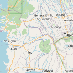
Distance Map Between Indang and Lucena
Indang, Calamba, Philippines ↔ Lucena, Calamba, Philippines = 53 miles = 85 km.


How far is it between Indang and Lucena
Indang is located in Philippines with (14.1953,120.8769) coordinates and Lucena is located in Philippines with (13.9314,121.6172) coordinates. The calculated flying distance from Indang to Lucena is equal to 53 miles which is equal to 85 km.
If you want to go by car, the driving distance between Indang and Lucena is 129.86 km. If you ride your car with an average speed of 112 kilometers/hour (70 miles/h), travel time will be 01 hours 09 minutes. Please check the avg. speed travel time table on the right for various options.
Difference between fly and go by a car is 45 km.
| City/Place | Latitude and Longitude | GPS Coordinates |
|---|---|---|
| Indang | 14.1953, 120.8769 | 14° 11´ 43.0080'' N 120° 52´ 36.9840'' E |
| Lucena | 13.9314, 121.6172 | 13° 55´ 53.0040'' N 121° 37´ 1.9920'' E |
Estimated Travel Time Between Indang and Lucena
| Average Speed | Travel Time |
|---|---|
| 30 mph (48 km/h) | 02 hours 42 minutes |
| 40 mph (64 km/h) | 02 hours 01 minutes |
| 50 mph (80 km/h) | 01 hours 37 minutes |
| 60 mph (97 km/h) | 01 hours 20 minutes |
| 70 mph (112 km/h) | 01 hours 09 minutes |
| 75 mph (120 km/h) | 01 hours 04 minutes |
Related Distances from Indang
| Cities | Distance |
|---|---|
| Indang to Silang | 13 km |
| Indang to Naic | 19 km |
| Indang to Taal | 49 km |
| Indang to Kawit | 34 km |
| Indang to Ternate 2 | 26 km |
Related Distances to Lucena
| Cities | Distance |
|---|---|
| Batangas to Lucena | 82 km |
| Lucban to Lucena | 25 km |
| Gumaca to Lucena | 64 km |
| Lopez to Lucena | 84 km |
| Atimonan to Lucena | 41 km |