Distance from Irati to Paranavai
Distance between Irati and Paranavai is 324 kilometers (201 miles).
Driving distance from Irati to Paranavai is 463 kilometers (288 miles).
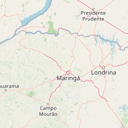
Distance Map Between Irati and Paranavai
Irati, Curitiba, Brazil ↔ Paranavai, Curitiba, Brazil = 201 miles = 324 km.


How far is it between Irati and Paranavaí
Irati is located in Brazil with (-25.4672,-50.6511) coordinates and Paranavai is located in Brazil with (-23.0731,-52.4653) coordinates. The calculated flying distance from Irati to Paranavai is equal to 201 miles which is equal to 324 km.
If you want to go by car, the driving distance between Irati and Paranavai is 463.04 km. If you ride your car with an average speed of 112 kilometers/hour (70 miles/h), travel time will be 04 hours 08 minutes. Please check the avg. speed travel time table on the right for various options.
Difference between fly and go by a car is 139 km.
| City/Place | Latitude and Longitude | GPS Coordinates |
|---|---|---|
| Irati | -25.4672, -50.6511 | 25° 28´ 1.9920'' S 50° 39´ 3.9960'' W |
| Paranavai | -23.0731, -52.4653 | 23° 4´ 23.0160'' S 52° 27´ 55.0080'' W |
Estimated Travel Time Between Irati and Paranavaí
| Average Speed | Travel Time |
|---|---|
| 30 mph (48 km/h) | 09 hours 38 minutes |
| 40 mph (64 km/h) | 07 hours 14 minutes |
| 50 mph (80 km/h) | 05 hours 47 minutes |
| 60 mph (97 km/h) | 04 hours 46 minutes |
| 70 mph (112 km/h) | 04 hours 08 minutes |
| 75 mph (120 km/h) | 03 hours 51 minutes |
Related Distances from Irati
| Cities | Distance |
|---|---|
| Irati to Sao Mateus Do Sul | 60 km |
| Irati to Uniao Da Vitoria | 124 km |
| Irati to Paranagua | 255 km |
| Irati to Telemaco Borba | 196 km |
| Irati to Umuarama | 410 km |
Related Distances to Paranavai
| Cities | Distance |
|---|---|
| Marialva to Paranavai | 98 km |
| Almirante Tamandare to Paranavai | 511 km |
| Dois Vizinhos to Paranavai | 468 km |
| Londrina to Paranavai | 165 km |
| Maringa to Paranavai | 74 km |