Distance from Koeln to Stolberg
Distance between Koeln and Stolberg is 54 kilometers (33 miles).
Driving distance from Koeln to Stolberg is 65 kilometers (40 miles).
Distance Map Between Koeln and Stolberg
Koeln, Dusseldorf, Germany ↔ Stolberg, Dusseldorf, Germany = 33 miles = 54 km.


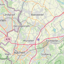


How far is it between Köln and Stolberg
Koeln is located in Germany with (50.9333,6.95) coordinates and Stolberg is located in Germany with (50.7737,6.226) coordinates. The calculated flying distance from Koeln to Stolberg is equal to 33 miles which is equal to 54 km.
If you want to go by car, the driving distance between Koeln and Stolberg is 64.83 km. If you ride your car with an average speed of 112 kilometers/hour (70 miles/h), travel time will be 00 hours 34 minutes. Please check the avg. speed travel time table on the right for various options.
Difference between fly and go by a car is 11 km.
| City/Place | Latitude and Longitude | GPS Coordinates |
|---|---|---|
| Koeln | 50.9333, 6.95 | 50° 55´ 59.9880'' N 6° 57´ 0.0000'' E |
| Stolberg | 50.7737, 6.226 | 50° 46´ 25.2480'' N 6° 13´ 33.4200'' E |
Estimated Travel Time Between Köln and Stolberg
| Average Speed | Travel Time |
|---|---|
| 30 mph (48 km/h) | 01 hours 21 minutes |
| 40 mph (64 km/h) | 01 hours 00 minutes |
| 50 mph (80 km/h) | 00 hours 48 minutes |
| 60 mph (97 km/h) | 00 hours 40 minutes |
| 70 mph (112 km/h) | 00 hours 34 minutes |
| 75 mph (120 km/h) | 00 hours 32 minutes |
Related Distances from Koeln
| Cities | Distance |
|---|---|
| Koeln to Bad Laasphe | 137 km |
| Koeln to Konigswinter | 40 km |
| Koeln to Korschenbroich | 52 km |
| Koeln to Krefeld | 60 km |
| Koeln to Kreuztal | 89 km |
| Koeln to Kurten | 39 km |
| Koeln to Langenfeld | 28 km |
| Koeln to Leichlingen | 33 km |
| Koeln to Lemgo | 216 km |
| Koeln to Leopoldshohe | 203 km |
Related Distances to Stolberg
| Cities | Distance |
|---|---|
| Bonn to Stolberg | 85 km |
| Muenster to Stolberg | 205 km |
| Krefeld to Stolberg | 84 km |
| Aachen to Stolberg | 13 km |
| Solingen to Stolberg | 93 km |
| Dortmund to Stolberg | 150 km |
| Recklinghausen to Stolberg | 153 km |
| Siegburg to Stolberg | 92 km |
| Dueren to Stolberg | 28 km |
| Alsdorf to Stolberg | 18 km |