Distance from Kosonsoy to Pop
Distance between Kosonsoy and Pop is 56 kilometers (35 miles).
Driving distance from Kosonsoy to Pop is 61 kilometers (38 miles).
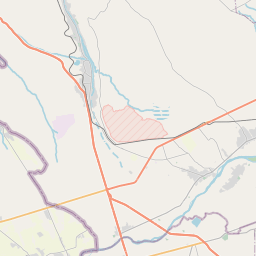
Distance Map Between Kosonsoy and Pop
Kosonsoy, Namangan, Uzbekistan ↔ Pop, Namangan, Uzbekistan = 35 miles = 56 km.


How far is it between Kosonsoy and Pop
Kosonsoy is located in Uzbekistan with (41.2561,71.5508) coordinates and Pop is located in Uzbekistan with (40.8736,71.1089) coordinates. The calculated flying distance from Kosonsoy to Pop is equal to 35 miles which is equal to 56 km.
If you want to go by car, the driving distance between Kosonsoy and Pop is 60.71 km. If you ride your car with an average speed of 112 kilometers/hour (70 miles/h), travel time will be 00 hours 32 minutes. Please check the avg. speed travel time table on the right for various options.
Difference between fly and go by a car is 5 km.
| City/Place | Latitude and Longitude | GPS Coordinates |
|---|---|---|
| Kosonsoy | 41.2561, 71.5508 | 41° 15´ 21.9960'' N 71° 33´ 2.9880'' E |
| Pop | 40.8736, 71.1089 | 40° 52´ 24.9960'' N 71° 6´ 32.0040'' E |
Estimated Travel Time Between Kosonsoy and Pop
| Average Speed | Travel Time |
|---|---|
| 30 mph (48 km/h) | 01 hours 15 minutes |
| 40 mph (64 km/h) | 00 hours 56 minutes |
| 50 mph (80 km/h) | 00 hours 45 minutes |
| 60 mph (97 km/h) | 00 hours 37 minutes |
| 70 mph (112 km/h) | 00 hours 32 minutes |
| 75 mph (120 km/h) | 00 hours 30 minutes |
Related Distances from Kosonsoy
| Cities | Distance |
|---|---|
| Kosonsoy to Pop | 61 km |
| Kosonsoy to Yangiqo Rg On | 28 km |
| Kosonsoy to Uychi | 53 km |
| Kosonsoy to Turagurghon | 31 km |
| Kosonsoy to Toshbuloq | 44 km |
Related Distances to Pop
| Cities | Distance |
|---|---|
| Chortoq to Pop | 76 km |
| Chust Shahri to Pop | 20 km |
| Kosonsoy to Pop | 61 km |
| Haqqulobod to Pop | 99 km |