Distance from Loveland to Pueblo
Distance between Loveland and Pueblo is 242 kilometers (150 miles).
Driving distance from Loveland to Pueblo is 263 kilometers (163 miles).
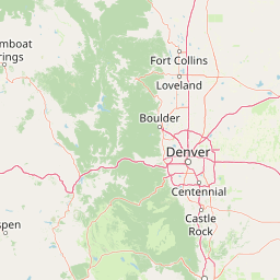
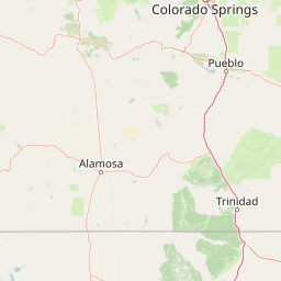
Distance Map Between Loveland and Pueblo
Loveland, Denver, United States ↔ Pueblo, Denver, United States = 150 miles = 242 km.


How far is it between Loveland and Pueblo
Loveland is located in United States with (40.3978,-105.075) coordinates and Pueblo is located in United States with (38.2545,-104.6091) coordinates. The calculated flying distance from Loveland to Pueblo is equal to 150 miles which is equal to 242 km.
If you want to go by car, the driving distance between Loveland and Pueblo is 262.85 km. If you ride your car with an average speed of 112 kilometers/hour (70 miles/h), travel time will be 02 hours 20 minutes. Please check the avg. speed travel time table on the right for various options.
Difference between fly and go by a car is 21 km.
| City/Place | Latitude and Longitude | GPS Coordinates |
|---|---|---|
| Loveland | 40.3978, -105.075 | 40° 23´ 51.9360'' N 105° 4´ 29.9280'' W |
| Pueblo | 38.2545, -104.6091 | 38° 15´ 16.0200'' N 104° 36´ 32.9040'' W |
Estimated Travel Time Between Loveland and Pueblo
| Average Speed | Travel Time |
|---|---|
| 30 mph (48 km/h) | 05 hours 28 minutes |
| 40 mph (64 km/h) | 04 hours 06 minutes |
| 50 mph (80 km/h) | 03 hours 17 minutes |
| 60 mph (97 km/h) | 02 hours 42 minutes |
| 70 mph (112 km/h) | 02 hours 20 minutes |
| 75 mph (120 km/h) | 02 hours 11 minutes |
Related Distances from Loveland
| Cities | Distance |
|---|---|
| Loveland to Fort Collins | 24 km |
| Loveland to Colorado Springs | 193 km |
| Loveland to Boulder | 53 km |
| Loveland to Brighton 3 | 66 km |
| Loveland to Broomfield | 67 km |
Related Distances to Pueblo
| Cities | Distance |
|---|---|
| Fort Collins to Pueblo | 284 km |
| Boulder to Pueblo | 226 km |
| Loveland to Pueblo | 263 km |
| Boulder to Pueblo West | 223 km |
| Longmont to Pueblo | 241 km |