Distance from Managua to Patzcuaro
Distance between Managua and Patzcuaro is 1835 kilometers (1140 miles).
Distance Map Between Managua and Patzcuaro
Managua, Nicaragua ↔ Patzcuaro, Morelia, Mexico = 1140 miles = 1835 km.

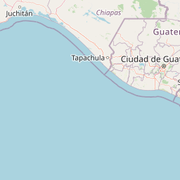


Leaflet | © OpenStreetMap
How far is it between Managua and Pátzcuaro
Managua is located in Nicaragua with (12.1328,-86.2504) coordinates and Patzcuaro is located in Mexico with (19.5159,-101.6089) coordinates. The calculated flying distance from Managua to Patzcuaro is equal to 1140 miles which is equal to 1835 km.
| City/Place | Latitude and Longitude | GPS Coordinates |
|---|---|---|
| Managua | 12.1328, -86.2504 | 12° 7´ 58.1520'' N 86° 15´ 1.4400'' W |
| Patzcuaro | 19.5159, -101.6089 | 19° 30´ 57.3840'' N 101° 36´ 31.9320'' W |
Managua, Nicaragua
Related Distances from Managua
| Cities | Distance |
|---|---|
| Managua to Mexico City | 2098 km |
| Managua to Leon | 2516 km |
| Managua to Cancun | 1676 km |
| Managua to Tapachula | 1017 km |
| Managua to Guadalajara | 2635 km |
Patzcuaro, Morelia, Mexico
Related Distances to Patzcuaro
| Cities | Distance |
|---|---|
| Ciudad Lazaro Cardenas to Patzcuaro | 263 km |
| Paracho De Verduzco to Patzcuaro | 67 km |
| Heroica Zitacuaro to Patzcuaro | 229 km |
| La Piedad Cavadas to Patzcuaro | 187 km |
| Apatzingan to Patzcuaro | 136 km |