Distance from Manassas to Herndon
Distance between Manassas and Herndon is 26 kilometers (16 miles).
Driving distance from Manassas to Herndon is 32 kilometers (20 miles).
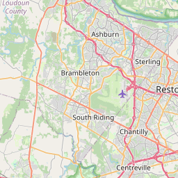
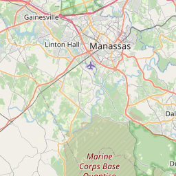
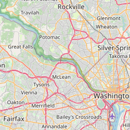
Distance Map Between Manassas and Herndon
Manassas, Richmond, United States ↔ Herndon, Richmond, United States = 16 miles = 26 km.

How far is it between Manassas and Herndon
Manassas is located in United States with (38.751,-77.4753) coordinates and Herndon is located in United States with (38.9696,-77.3861) coordinates. The calculated flying distance from Manassas to Herndon is equal to 16 miles which is equal to 26 km.
If you want to go by car, the driving distance between Manassas and Herndon is 31.6 km. If you ride your car with an average speed of 112 kilometers/hour (70 miles/h), travel time will be 00 hours 16 minutes. Please check the avg. speed travel time table on the right for various options.
Difference between fly and go by a car is 6 km.
| City/Place | Latitude and Longitude | GPS Coordinates |
|---|---|---|
| Manassas | 38.751, -77.4753 | 38° 45´ 3.4200'' N 77° 28´ 30.9720'' W |
| Herndon | 38.9696, -77.3861 | 38° 58´ 10.3800'' N 77° 23´ 9.9600'' W |
Estimated Travel Time Between Manassas and Herndon
| Average Speed | Travel Time |
|---|---|
| 30 mph (48 km/h) | 00 hours 39 minutes |
| 40 mph (64 km/h) | 00 hours 29 minutes |
| 50 mph (80 km/h) | 00 hours 23 minutes |
| 60 mph (97 km/h) | 00 hours 19 minutes |
| 70 mph (112 km/h) | 00 hours 16 minutes |
| 75 mph (120 km/h) | 00 hours 15 minutes |
Related Distances from Manassas
| Cities | Distance |
|---|---|
| Manassas to Alexandria 2 | 56 km |
| Manassas to Annandale | 38 km |
| Manassas to Arlington 2 | 42 km |
| Manassas to Ashburn | 38 km |
| Manassas to Baileys Crossroads | 44 km |
| Manassas to Blacksburg | 392 km |
| Manassas to Bon Air | 158 km |
| Manassas to Bristol 5 | 564 km |
| Manassas to Burke | 24 km |
| Manassas to Cave Spring | 356 km |
Related Distances to Herndon
| Cities | Distance |
|---|---|
| Virginia Beach to Herndon | 351 km |
| South Riding to Herndon | 19 km |
| Petersburg to Herndon | 228 km |
| Suffolk to Herndon | 325 km |
| Tysons Corner to Herndon | 17 km |
| Newport News to Herndon | 308 km |
| Norfolk to Herndon | 329 km |
| Springfield 6 to Herndon | 39 km |
| Oakton to Herndon | 16 km |
| Roanoke to Herndon | 368 km |