Distance from Mao to Sagh
Distance between Mao and Sagh is 647 kilometers (402 miles).
Driving distance from Mao to Sagh is 872 kilometers (542 miles).
Distance Map Between Mao and Sagh
Mao, Chad ↔ Sagh, Chad = 402 miles = 647 km.


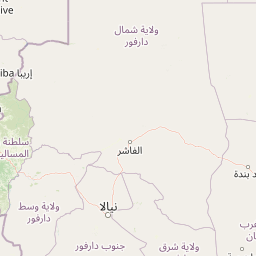

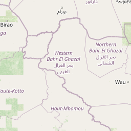

Leaflet | © OpenStreetMap
How far is it between Mao and Sagh
Mao is located in Chad with (14.1212,15.3103) coordinates and Sagh is located in Chad with (9.1429,18.3923) coordinates. The calculated flying distance from Mao to Sagh is equal to 402 miles which is equal to 647 km.
If you want to go by car, the driving distance between Mao and Sagh is 871.58 km. If you ride your car with an average speed of 112 kilometers/hour (70 miles/h), travel time will be 07 hours 46 minutes. Please check the avg. speed travel time table on the right for various options.
Difference between fly and go by a car is 225 km.
| City/Place | Latitude and Longitude | GPS Coordinates |
|---|---|---|
| Mao | 14.1212, 15.3103 | 14° 7´ 16.1760'' N 15° 18´ 37.0800'' E |
| Sagh | 9.1429, 18.3923 | 9° 8´ 34.4400'' N 18° 23´ 32.2800'' E |
Estimated Travel Time Between Mao and Sagh
| Average Speed | Travel Time |
|---|---|
| 30 mph (48 km/h) | 18 hours 09 minutes |
| 40 mph (64 km/h) | 13 hours 37 minutes |
| 50 mph (80 km/h) | 10 hours 53 minutes |
| 60 mph (97 km/h) | 08 hours 59 minutes |
| 70 mph (112 km/h) | 07 hours 46 minutes |
| 75 mph (120 km/h) | 07 hours 15 minutes |
Mao, Chad
Related Distances from Mao
| Cities | Distance |
|---|---|
| Mao 3 to N Djamena | 314 km |
| Mao 3 to Pala | 742 km |
| Mao 3 to Massakory | 167 km |
| Mao 3 to Moundou | 786 km |
| Mao 3 to Moussoro | 447 km |
Sagh, Chad
Related Distances to Sagh
| Cities | Distance |
|---|---|
| Koumra to Sagh | 114 km |
| Bongor to Sagh | 425 km |
| Ati to Sagh | 717 km |
| N Djamena to Sagh | 561 km |
| Lai to Sagh | 277 km |