Distance from Masaki-cho to Shantou
Distance between Masaki-cho and Shantou is 1940 kilometers (1206 miles).
Distance Map Between Masaki-cho and Shantou
Masaki-cho, Matsuyama, Japan ↔ Shantou, Guangzhou, China = 1206 miles = 1940 km.
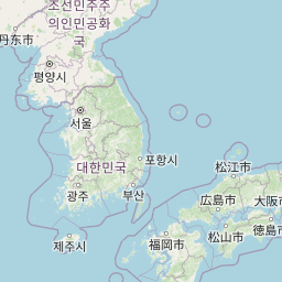


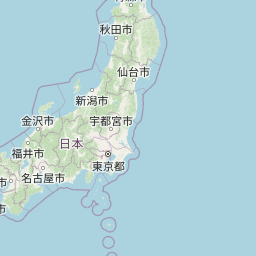


Leaflet | © OpenStreetMap
How far is it between Masaki-chō and Shantou
Masaki-cho is located in Japan with (33.7876,132.7112) coordinates and Shantou is located in China with (23.3681,116.7148) coordinates. The calculated flying distance from Masaki-cho to Shantou is equal to 1206 miles which is equal to 1940 km.
| City/Place | Latitude and Longitude | GPS Coordinates |
|---|---|---|
| Masaki-cho | 33.7876, 132.7112 | 33° 47´ 15.2520'' N 132° 42´ 40.4640'' E |
| Shantou | 23.3681, 116.7148 | 23° 22´ 5.3040'' N 116° 42´ 53.2440'' E |
Masaki-cho, Matsuyama, Japan
Related Distances from Masaki-cho
| Cities | Distance |
|---|---|
| Masaki Cho to Uwajima | 80 km |
| Masaki Cho to Niihama | 71 km |
| Masaki Cho to Saijo | 55 km |
| Masaki Cho to Iyo | 6 km |
| Masaki Cho to Ozu | 44 km |
Shantou, Guangzhou, China
Related Distances to Shantou
| Cities | Distance |
|---|---|
| Chaozhou to Shantou | 49 km |
| Jieyang to Shantou | 49 km |
| Dongguan to Shantou | 383 km |
| Meizhou to Shantou | 158 km |
| Foshan to Shantou | 463 km |