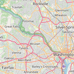
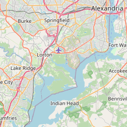
Distance from McLean to Lorton
Distance between McLean and Lorton is 26 kilometers (16 miles).
Driving distance from McLean to Lorton is 33 kilometers (20 miles).
Distance Map Between McLean and Lorton
McLean, Richmond, United States ↔ Lorton, Richmond, United States = 16 miles = 26 km.


How far is it between McLean and Lorton
McLean is located in United States with (38.9343,-77.1775) coordinates and Lorton is located in United States with (38.7043,-77.2278) coordinates. The calculated flying distance from McLean to Lorton is equal to 16 miles which is equal to 26 km.
If you want to go by car, the driving distance between McLean and Lorton is 32.7 km. If you ride your car with an average speed of 112 kilometers/hour (70 miles/h), travel time will be 00 hours 17 minutes. Please check the avg. speed travel time table on the right for various options.
Difference between fly and go by a car is 7 km.
| City/Place | Latitude and Longitude | GPS Coordinates |
|---|---|---|
| McLean | 38.9343, -77.1775 | 38° 56´ 3.4080'' N 77° 10´ 38.9280'' W |
| Lorton | 38.7043, -77.2278 | 38° 42´ 15.4080'' N 77° 13´ 39.9360'' W |
Estimated Travel Time Between McLean and Lorton
| Average Speed | Travel Time |
|---|---|
| 30 mph (48 km/h) | 00 hours 40 minutes |
| 40 mph (64 km/h) | 00 hours 30 minutes |
| 50 mph (80 km/h) | 00 hours 24 minutes |
| 60 mph (97 km/h) | 00 hours 20 minutes |
| 70 mph (112 km/h) | 00 hours 17 minutes |
| 75 mph (120 km/h) | 00 hours 16 minutes |
Related Distances from McLean
| Cities | Distance |
|---|---|
| Mclean to Ashburn | 38 km |
| Mclean to Fairfax | 20 km |
| Mclean to Leesburg | 47 km |
| Mclean to Herndon | 21 km |
| Mclean to Alexandria 2 | 25 km |
Related Distances to Lorton
| Cities | Distance |
|---|---|
| Staunton to Lorton | 243 km |
| Sterling to Lorton | 56 km |
| Tysons Corner to Lorton | 30 km |
| Waynesboro to Lorton | 201 km |
| Reston to Lorton | 46 km |