Distance from Millville to Quebec
Distance between Millville and Quebec is 880 kilometers (547 miles).
Driving distance from Millville to Quebec is 1020 kilometers (634 miles).
Distance Map Between Millville and Quebec
Millville, Trenton, United States ↔ Quebec, Canada = 547 miles = 880 km.


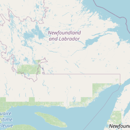


How far is it between Millville and Québec
Millville is located in United States with (39.4021,-75.0393) coordinates and Quebec is located in Canada with (46.8123,-71.2145) coordinates. The calculated flying distance from Millville to Quebec is equal to 547 miles which is equal to 880 km.
If you want to go by car, the driving distance between Millville and Quebec is 1019.99 km. If you ride your car with an average speed of 112 kilometers/hour (70 miles/h), travel time will be 09 hours 06 minutes. Please check the avg. speed travel time table on the right for various options.
Difference between fly and go by a car is 140 km.
| City/Place | Latitude and Longitude | GPS Coordinates |
|---|---|---|
| Millville | 39.4021, -75.0393 | 39° 24´ 7.4160'' N 75° 2´ 21.6240'' W |
| Quebec | 46.8123, -71.2145 | 46° 48´ 44.2080'' N 71° 12´ 52.3440'' W |
Estimated Travel Time Between Millville and Québec
| Average Speed | Travel Time |
|---|---|
| 30 mph (48 km/h) | 21 hours 14 minutes |
| 40 mph (64 km/h) | 15 hours 56 minutes |
| 50 mph (80 km/h) | 12 hours 44 minutes |
| 60 mph (97 km/h) | 10 hours 30 minutes |
| 70 mph (112 km/h) | 09 hours 06 minutes |
| 75 mph (120 km/h) | 08 hours 29 minutes |
Related Distances from Millville
| Cities | Distance |
|---|---|
| Millville to Toronto | 885 km |
| Millville to Halifax | 1596 km |
| Millville to Hamilton | 818 km |
| Millville to Vaughan | 896 km |
| Millville to Ottawa | 791 km |
Related Distances to Quebec
| Cities | Distance |
|---|---|
| New York City to Quebec | 835 km |
| Boston to Quebec | 639 km |
| Niagara Falls 2 to Quebec | 918 km |
| Washington D C to Quebec | 1181 km |
| New Brunswick to Quebec | 871 km |