Distance from Mirabel to Laval
Distance between Mirabel and Laval is 32 kilometers (20 miles).
Driving distance from Mirabel to Laval is 42 kilometers (26 miles).
Distance Map Between Mirabel and Laval
Mirabel, Quebec, Canada ↔ Laval, Quebec, Canada = 20 miles = 32 km.


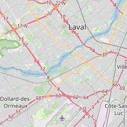


How far is it between Mirabel and Laval
Mirabel is located in Canada with (45.6501,-74.0825) coordinates and Laval is located in Canada with (45.57,-73.692) coordinates. The calculated flying distance from Mirabel to Laval is equal to 20 miles which is equal to 32 km.
If you want to go by car, the driving distance between Mirabel and Laval is 41.71 km. If you ride your car with an average speed of 112 kilometers/hour (70 miles/h), travel time will be 00 hours 22 minutes. Please check the avg. speed travel time table on the right for various options.
Difference between fly and go by a car is 10 km.
| City/Place | Latitude and Longitude | GPS Coordinates |
|---|---|---|
| Mirabel | 45.6501, -74.0825 | 45° 39´ 0.2880'' N 74° 4´ 57.0360'' W |
| Laval | 45.57, -73.692 | 45° 34´ 11.8200'' N 73° 41´ 31.2000'' W |
Estimated Travel Time Between Mirabel and Laval
| Average Speed | Travel Time |
|---|---|
| 30 mph (48 km/h) | 00 hours 52 minutes |
| 40 mph (64 km/h) | 00 hours 39 minutes |
| 50 mph (80 km/h) | 00 hours 31 minutes |
| 60 mph (97 km/h) | 00 hours 25 minutes |
| 70 mph (112 km/h) | 00 hours 22 minutes |
| 75 mph (120 km/h) | 00 hours 20 minutes |
Related Distances from Mirabel
| Cities | Distance |
|---|---|
| Mirabel to Gatineau | 149 km |
| Mirabel to Blainville | 23 km |
| Mirabel to Laval | 42 km |
| Mirabel to Brossard | 68 km |
| Mirabel to Boisbriand | 28 km |
Related Distances to Laval
| Cities | Distance |
|---|---|
| Montreal to Laval | 13 km |
| Saint Jerome to Laval | 41 km |
| Saint Laurent to Laval | 14 km |
| Saint Hyacinthe to Laval | 65 km |
| Saint Eustache to Laval | 24 km |