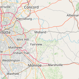
Distance from Monroe to Cary
Distance between Monroe and Cary is 184 kilometers (114 miles).
Driving distance from Monroe to Cary is 226 kilometers (140 miles).
Distance Map Between Monroe and Cary
Monroe, Raleigh, United States ↔ Cary, Raleigh, United States = 114 miles = 184 km.


How far is it between Monroe and Cary
Monroe is located in United States with (34.9854,-80.5495) coordinates and Cary is located in United States with (35.7915,-78.7811) coordinates. The calculated flying distance from Monroe to Cary is equal to 114 miles which is equal to 184 km.
If you want to go by car, the driving distance between Monroe and Cary is 225.97 km. If you ride your car with an average speed of 112 kilometers/hour (70 miles/h), travel time will be 02 hours 01 minutes. Please check the avg. speed travel time table on the right for various options.
Difference between fly and go by a car is 42 km.
| City/Place | Latitude and Longitude | GPS Coordinates |
|---|---|---|
| Monroe | 34.9854, -80.5495 | 34° 59´ 7.5480'' N 80° 32´ 58.2360'' W |
| Cary | 35.7915, -78.7811 | 35° 47´ 29.5440'' N 78° 46´ 52.0320'' W |
Estimated Travel Time Between Monroe and Cary
| Average Speed | Travel Time |
|---|---|
| 30 mph (48 km/h) | 04 hours 42 minutes |
| 40 mph (64 km/h) | 03 hours 31 minutes |
| 50 mph (80 km/h) | 02 hours 49 minutes |
| 60 mph (97 km/h) | 02 hours 19 minutes |
| 70 mph (112 km/h) | 02 hours 01 minutes |
| 75 mph (120 km/h) | 01 hours 52 minutes |
Related Distances from Monroe
| Cities | Distance |
|---|---|
| Monroe 2 to Charlotte | 40 km |
| Monroe 2 to Greensboro | 175 km |
| Monroe 2 to Burlington 2 | 208 km |
| Monroe 2 to Matthews | 24 km |
| Monroe 2 to Concord 2 | 52 km |
Related Distances to Cary
| Cities | Distance |
|---|---|
| Clayton to Cary | 40 km |
| Durham to Cary | 30 km |
| Charlotte to Cary | 257 km |
| Chapel Hill to Cary | 36 km |
| Elgin to Cary 2 | 25 km |