Distance from Monroe to Delta
Distance between Monroe and Delta is 159 kilometers (99 miles).
Driving distance from Monroe to Delta is 181 kilometers (113 miles).
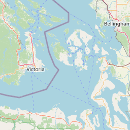
Distance Map Between Monroe and Delta
Monroe, Olympia, United States ↔ Delta, Victoria, Canada = 99 miles = 159 km.


How far is it between Monroe and Delta
Monroe is located in United States with (47.8554,-121.971) coordinates and Delta is located in Canada with (49.144,-122.9068) coordinates. The calculated flying distance from Monroe to Delta is equal to 99 miles which is equal to 159 km.
If you want to go by car, the driving distance between Monroe and Delta is 181.43 km. If you ride your car with an average speed of 112 kilometers/hour (70 miles/h), travel time will be 01 hours 37 minutes. Please check the avg. speed travel time table on the right for various options.
Difference between fly and go by a car is 22 km.
| City/Place | Latitude and Longitude | GPS Coordinates |
|---|---|---|
| Monroe | 47.8554, -121.971 | 47° 51´ 19.3680'' N 121° 58´ 15.4560'' W |
| Delta | 49.144, -122.9068 | 49° 8´ 38.3640'' N 122° 54´ 24.4800'' W |
Estimated Travel Time Between Monroe and Delta
| Average Speed | Travel Time |
|---|---|
| 30 mph (48 km/h) | 03 hours 46 minutes |
| 40 mph (64 km/h) | 02 hours 50 minutes |
| 50 mph (80 km/h) | 02 hours 16 minutes |
| 60 mph (97 km/h) | 01 hours 52 minutes |
| 70 mph (112 km/h) | 01 hours 37 minutes |
| 75 mph (120 km/h) | 01 hours 30 minutes |
Related Distances from Monroe
| Cities | Distance |
|---|---|
| Monroe 4 to Abbotsford | 165 km |
| Monroe 4 to Anmore | 201 km |
| Monroe 4 to Burnaby | 198 km |
| Monroe 4 to Calgary | 1058 km |
| Monroe 4 to Chilliwack | 191 km |
| Monroe 4 to Coquitlam | 196 km |
| Monroe 4 to Delta | 181 km |
| Monroe 4 to Edmonton | 1253 km |
| Monroe 4 to Fort Mcmurray | 1678 km |
| Monroe 4 to Kelowna | 478 km |
Related Distances to Delta
| Cities | Distance |
|---|---|
| Coeur D Alene to Delta | 694 km |
| Spokane to Delta | 641 km |
| Sacramento to Delta | 1414 km |
| San Jose to Delta | 1557 km |
| Bremerton to Delta | 307 km |
| Oak Harbor to Delta | 144 km |
| Seattle to Delta | 203 km |
| Lynnwood to Delta | 181 km |
| Seatac to Delta | 225 km |
| Bakersfield to Delta | 1860 km |