Distance from Orange to Galveston
Distance between Orange and Galveston is 135 kilometers (84 miles).
Driving distance from Orange to Galveston is 213 kilometers (133 miles).
Distance Map Between Orange and Galveston
Orange, Austin, United States ↔ Galveston, Austin, United States = 84 miles = 135 km.

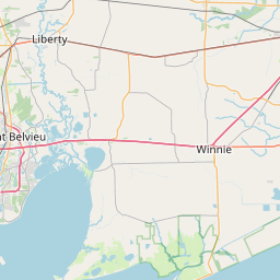
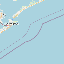


How far is it between Orange and Galveston
Orange is located in United States with (30.093,-93.7366) coordinates and Galveston is located in United States with (29.3014,-94.7977) coordinates. The calculated flying distance from Orange to Galveston is equal to 84 miles which is equal to 135 km.
If you want to go by car, the driving distance between Orange and Galveston is 213.42 km. If you ride your car with an average speed of 112 kilometers/hour (70 miles/h), travel time will be 01 hours 54 minutes. Please check the avg. speed travel time table on the right for various options.
Difference between fly and go by a car is 78 km.
| City/Place | Latitude and Longitude | GPS Coordinates |
|---|---|---|
| Orange | 30.093, -93.7366 | 30° 5´ 34.7640'' N 93° 44´ 11.5800'' W |
| Galveston | 29.3014, -94.7977 | 29° 18´ 4.8600'' N 94° 47´ 51.7200'' W |
Estimated Travel Time Between Orange and Galveston
| Average Speed | Travel Time |
|---|---|
| 30 mph (48 km/h) | 04 hours 26 minutes |
| 40 mph (64 km/h) | 03 hours 20 minutes |
| 50 mph (80 km/h) | 02 hours 40 minutes |
| 60 mph (97 km/h) | 02 hours 12 minutes |
| 70 mph (112 km/h) | 01 hours 54 minutes |
| 75 mph (120 km/h) | 01 hours 46 minutes |
Related Distances from Orange
| Cities | Distance |
|---|---|
| Orange 5 to Houston | 183 km |
| Orange 5 to Galveston | 213 km |
| Orange 5 to Beaumont | 43 km |
| Orange 5 to Grapevine | 537 km |
| Orange 5 to Corpus Christi | 515 km |
Related Distances to Galveston
| Cities | Distance |
|---|---|
| Houston to Galveston | 84 km |
| Texas City to Galveston | 22 km |
| San Antonio to Galveston | 398 km |
| Port Arthur to Galveston | 134 km |
| Sugar Land to Galveston | 103 km |