Distance from Owasso to Moore
Distance between Owasso and Moore is 180 kilometers (112 miles).
Driving distance from Owasso to Moore is 205 kilometers (127 miles).
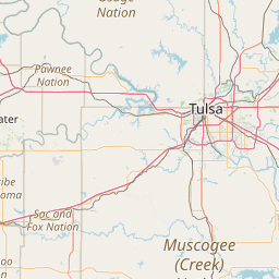
Distance Map Between Owasso and Moore
Owasso, Oklahoma City, United States ↔ Moore, Oklahoma City, United States = 112 miles = 180 km.


How far is it between Owasso and Moore
Owasso is located in United States with (36.2695,-95.8547) coordinates and Moore is located in United States with (35.3395,-97.4867) coordinates. The calculated flying distance from Owasso to Moore is equal to 112 miles which is equal to 180 km.
If you want to go by car, the driving distance between Owasso and Moore is 204.87 km. If you ride your car with an average speed of 112 kilometers/hour (70 miles/h), travel time will be 01 hours 49 minutes. Please check the avg. speed travel time table on the right for various options.
Difference between fly and go by a car is 25 km.
| City/Place | Latitude and Longitude | GPS Coordinates |
|---|---|---|
| Owasso | 36.2695, -95.8547 | 36° 16´ 10.3440'' N 95° 51´ 16.9560'' W |
| Moore | 35.3395, -97.4867 | 35° 20´ 22.2360'' N 97° 29´ 12.1200'' W |
Estimated Travel Time Between Owasso and Moore
| Average Speed | Travel Time |
|---|---|
| 30 mph (48 km/h) | 04 hours 16 minutes |
| 40 mph (64 km/h) | 03 hours 12 minutes |
| 50 mph (80 km/h) | 02 hours 33 minutes |
| 60 mph (97 km/h) | 02 hours 06 minutes |
| 70 mph (112 km/h) | 01 hours 49 minutes |
| 75 mph (120 km/h) | 01 hours 42 minutes |
Related Distances from Owasso
| Cities | Distance |
|---|---|
| Owasso to Broken Arrow | 29 km |
| Owasso to Bixby | 40 km |
| Owasso to Claremore | 27 km |
| Owasso to Bartlesville | 63 km |
| Owasso to Muskogee | 84 km |
Related Distances to Moore
| Cities | Distance |
|---|---|
| Yukon to Moore | 42 km |
| Shawnee 2 to Moore | 64 km |
| Morganton to Mooresville | 109 km |
| Ponca City to Moore | 182 km |
| Winston Salem to Mooresville | 97 km |