Distance from Pelileo to Quito
Distance between Pelileo and Quito is 122 kilometers (76 miles).
Driving distance from Pelileo to Quito is 151 kilometers (94 miles).
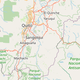
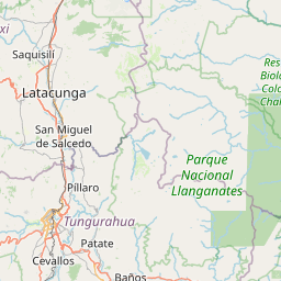
Distance Map Between Pelileo and Quito
Pelileo, Ambato, Ecuador ↔ Quito, Ecuador = 76 miles = 122 km.


How far is it between Pelileo and Quito
Pelileo is located in Ecuador with (-1.3299,-78.5434) coordinates and Quito is located in Ecuador with (-0.2299,-78.525) coordinates. The calculated flying distance from Pelileo to Quito is equal to 76 miles which is equal to 122 km.
If you want to go by car, the driving distance between Pelileo and Quito is 151.11 km. If you ride your car with an average speed of 112 kilometers/hour (70 miles/h), travel time will be 01 hours 20 minutes. Please check the avg. speed travel time table on the right for various options.
Difference between fly and go by a car is 29 km.
| City/Place | Latitude and Longitude | GPS Coordinates |
|---|---|---|
| Pelileo | -1.3299, -78.5434 | 1° 19´ 47.6400'' S 78° 32´ 36.2760'' W |
| Quito | -0.2299, -78.525 | 0° 13´ 47.4600'' S 78° 31´ 29.8200'' W |
Estimated Travel Time Between Pelileo and Quito
| Average Speed | Travel Time |
|---|---|
| 30 mph (48 km/h) | 03 hours 08 minutes |
| 40 mph (64 km/h) | 02 hours 21 minutes |
| 50 mph (80 km/h) | 01 hours 53 minutes |
| 60 mph (97 km/h) | 01 hours 33 minutes |
| 70 mph (112 km/h) | 01 hours 20 minutes |
| 75 mph (120 km/h) | 01 hours 15 minutes |
Related Distances from Pelileo
| Cities | Distance |
|---|---|
| Pelileo to Quito | 151 km |
| Pelileo to Tena | 159 km |
| Pelileo to Riobamba | 56 km |
| Pelileo to Portoviejo | 369 km |
| Pelileo to Santa Elena | 403 km |
Related Distances to Quito
| Cities | Distance |
|---|---|
| Guayaquil to Quito | 412 km |
| Cuenca to Quito | 440 km |
| Ibarra to Quito | 124 km |
| Ambato to Quito | 134 km |
| Loja to Quito | 643 km |