Distance from Sanford to Port Orange
Distance between Sanford and Port Orange is 46 kilometers (29 miles).
Driving distance from Sanford to Port Orange is 65 kilometers (40 miles).
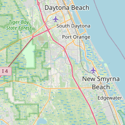
Distance Map Between Sanford and Port Orange
Sanford, Tallahassee, United States ↔ Port Orange, Tallahassee, United States = 29 miles = 46 km.


How far is it between Sanford and Port Orange
Sanford is located in United States with (28.8006,-81.2731) coordinates and Port Orange is located in United States with (29.1383,-80.9956) coordinates. The calculated flying distance from Sanford to Port Orange is equal to 29 miles which is equal to 46 km.
If you want to go by car, the driving distance between Sanford and Port Orange is 64.77 km. If you ride your car with an average speed of 112 kilometers/hour (70 miles/h), travel time will be 00 hours 34 minutes. Please check the avg. speed travel time table on the right for various options.
Difference between fly and go by a car is 19 km.
| City/Place | Latitude and Longitude | GPS Coordinates |
|---|---|---|
| Sanford | 28.8006, -81.2731 | 28° 48´ 1.9800'' N 81° 16´ 23.2320'' W |
| Port Orange | 29.1383, -80.9956 | 29° 8´ 17.9520'' N 80° 59´ 44.1960'' W |
Estimated Travel Time Between Sanford and Port Orange
| Average Speed | Travel Time |
|---|---|
| 30 mph (48 km/h) | 01 hours 20 minutes |
| 40 mph (64 km/h) | 01 hours 00 minutes |
| 50 mph (80 km/h) | 00 hours 48 minutes |
| 60 mph (97 km/h) | 00 hours 40 minutes |
| 70 mph (112 km/h) | 00 hours 34 minutes |
| 75 mph (120 km/h) | 00 hours 32 minutes |
Related Distances from Sanford
| Cities | Distance |
|---|---|
| Sanford to Orlando | 43 km |
| Sanford to Daytona Beach | 61 km |
| Sanford to Ocala | 113 km |
| Sanford to Fort Lauderdale | 365 km |
| Sanford to Kissimmee | 77 km |
Related Distances to Port Orange
| Cities | Distance |
|---|---|
| Tampa to Port Orange | 228 km |
| Titusville to Port Orange | 68 km |
| Vero Beach to Port Orange | 193 km |
| Sanford to Port Orange | 65 km |
| Port Saint Lucie to Port Orange | 232 km |