Distance from Saugus to Easton
Distance between Saugus and Easton is 50 kilometers (31 miles).
Driving distance from Saugus to Easton is 63 kilometers (39 miles).
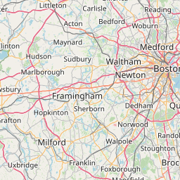
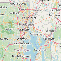
Distance Map Between Saugus and Easton
Saugus, Boston, United States ↔ Easton, Boston, United States = 31 miles = 50 km.


How far is it between Saugus and Easton
Saugus is located in United States with (42.4648,-71.0101) coordinates and Easton is located in United States with (42.0245,-71.1287) coordinates. The calculated flying distance from Saugus to Easton is equal to 31 miles which is equal to 50 km.
If you want to go by car, the driving distance between Saugus and Easton is 62.94 km. If you ride your car with an average speed of 112 kilometers/hour (70 miles/h), travel time will be 00 hours 33 minutes. Please check the avg. speed travel time table on the right for various options.
Difference between fly and go by a car is 13 km.
| City/Place | Latitude and Longitude | GPS Coordinates |
|---|---|---|
| Saugus | 42.4648, -71.0101 | 42° 27´ 53.3520'' N 71° 0´ 36.1800'' W |
| Easton | 42.0245, -71.1287 | 42° 1´ 28.3440'' N 71° 7´ 43.1760'' W |
Estimated Travel Time Between Saugus and Easton
| Average Speed | Travel Time |
|---|---|
| 30 mph (48 km/h) | 01 hours 18 minutes |
| 40 mph (64 km/h) | 00 hours 59 minutes |
| 50 mph (80 km/h) | 00 hours 47 minutes |
| 60 mph (97 km/h) | 00 hours 38 minutes |
| 70 mph (112 km/h) | 00 hours 33 minutes |
| 75 mph (120 km/h) | 00 hours 31 minutes |
Related Distances from Saugus
| Cities | Distance |
|---|---|
| Saugus to Burlington 5 | 24 km |
| Saugus to Peabody | 15 km |
| Saugus to Melrose | 6 km |
| Saugus to Billerica | 37 km |
| Saugus to Danvers | 19 km |
Related Distances to Easton
| Cities | Distance |
|---|---|
| Milford 2 to Easton 2 | 45 km |
| Norton 2 to Easton 2 | 9 km |
| Weymouth to Easton 2 | 40 km |
| Worcester to Easton 2 | 84 km |
| Framingham to Easton 2 | 65 km |